The 3 months public display period for the Sg. Buloh – Kajang line began on Monday, 14 February and continued until 15 May 2011. The public display period is now closed.
With the completion of the Public Display for MRT Line 1 (Sg. Buloh to Klang), TRANSIT will be revising this post to focus on the public display and alignment for MRT Line 1 only.
All articles about the MRT network in general and MRT project planning, management and delivery will be posted in our new post, MRT Update: Planning & Building the Klang Valley MRT.
The website for the Klang Valley MRT project is http://www.kvmrt.com.my/. Also note our note posting on the MRT Open Day! as well as our post on the Launching of the MRT on 8 July 2011. The most recent articles, plus more information including maps, videos, photos, comments and feedback after the jump!
Additional articles on the planning & development process for the MRT Sg. Buloh – Kajang MRT Line (updated frequently, most recent articles listed first). Please note that articles about the MRT planning process can be found in our post MRT Update: Planning & Building the Klang Valley MRT.
- MRT developer engages project delivery partner (The Star, 3 March 2012);
- MRT Corp inks deal with Jalan Sultan landowners (Business Times, 3 March 2012);
- Chinatown landowner strikes deals with MRT Corp (The Malaysian Insider, 2 March 2012);
- We will stop MRT work, say Jalan Sultan owners (The Malaysian Insider, 27 February 2012);
- Owners want meeting with MRT Corp (NST, 27 February 2012);
- Jalan Sultan shopowners worry over MRT Corp’s ultimatum (The Star, 27 february 2012);
- Traders must decide before MRT land acquisition (The Star, 25 February 2012);
- MRT Corp: MMC-Gamuda PDP deal will not bloat MRT cost (The Malaysian Insider, 24 February 2012);
- Tee Keat slams MRT Corp for ramrod approach (The Malaysian Insider, 24 February 2012);
- Month-end deadline for unhappy Chinatown traders (The Malaysian Insider, 24 February 2012);
- No change in MRT alignment’ (The Star, February 11, 2012);
- MRT Co speeding up the award of contracts (Star Biz, 4 February 2012);
- List on 90 packages of jobs from Sungai Buloh-Kajang MRT to be unveiled (The Star, 1 February 2012);
- Main contractors for elevated Sungai Buloh-Kajang MRT line confirmed (The Star, 1 February 2012);
- Public can still give views on MRT project in Jalan Sultan (The Star, 31 January 2012);
- Klang Valley folk to form coalition to tackle MRT woes (The Malaysian Insider, 13 January 2012
- Letter: Keep MRT under ground (The Star, 29 December 2011);
- Letter: Send MRT underground and DASH over it (The Sun Daily, 21 December 2011);
- Letter: Change will benefit the majority (The Star, 1 December 2011);
- TTDI traders hope for integration with MRT line (The Star, 29 November 2011);
- Six Cheras houses spared from MRT (Free Malaysian Today, 25 November 2011);
- MRT kiosks have all the answers (Streets – NST, 20 November 2011)
- MRT Co, city traders finalising deal to end land dispute (The Malaysian Insider, 16 November 2011);
- Huge transit project hits rough patch (Free Malaysia Today – via AFP – 4 November 2011);
- Landowners agree to cooperate with MRT Corp (Free Malaysia Today, 4 November 2011);
- Majority of owners and MRT Corp to pursue mutual agreement (The Star, 4 November 2011);
- Landowners slam MRT Co, say no U-turn on demands (The Malaysia Insider, 3 November 2011)
- MRT Corp says closer to ending city land dispute (The Malaysian Insider, 3 November 2011);
- CEO: Isu tanah projek MRT di pusat KL hampir selesai (The Malaysian Insider, Hb. 3 November 2011);
- The MRT effect on our lives and economy (NST, 2 November 2011) [TRANSIT: Note the interesting <a href=”http://www.nst.com.my/articles/4mrrtt/single“>graphic provided with the article];
- ‘MRT not SPAD’s concern anymore’ (Free Malaysia Today, 1 November 2011);
- MRT project: Landowners appeal to PM (The Malaysian Insider, 1 November 2011);
- A plea to Najib to save Chinatown, Bukit Bintang (Free Malaysia Today, 1 November 2011);
- MRT Co claims ‘bent over backwards’ to please Chinatown owners (The Malaysian Insider, 31 October 2011);
- MRT: It’ll add zest to Chinatown (NST, 24 October 2011);
- Jalan Peel squatters seek eviction deadline extension (The Star, 22 October 2011);
- Still haunted by MRT issues (The Star, 20 October 2011);
- Press Statement – Response to Allegation of MRT Alignment (KVMRT.com.my, 20 October 2011);
- MRT: Bukit Bintang traders go on signature drive (The Malaysian Insider, 18 October 2011);
- Tony Pua: The Controvercial MRT Land Acquistions (Mediarakyat, 16 October 2011);
- MRT Corp: We are not interested in taking people’s land (The Star, 15 October 2011);
- MRT: Tiada pengambilan tanah di Jalan Sultan (Komunitikini.com, hb. 14 Oktober 2011);
- Jalan Sultan landowners cautiously optimistic over MRT Co offer (The Malaysian Insider, 14 October 2011);
- Tony Pua: Civil pressure works to correct the wrongs (Komunitikini.com, 14 October 2011);
- Promise no surface land grabbed for MRT, Pua tells MRT Co (The Malaysian Insider, 14 October 2011);
- MRT Co backs down from land row (The Malaysian Insider, 14 October 2011);
- MRT Project – New owner trying out creative ways (Free Malaysia Today, 13 October 2011);
- ‘Chinatown will not be torn down‘ (Free Malaysia Today, 13 October 2011);
- Response to city land issues — MRT Corporation (The Malaysian Insider, 13 October 2011);
- Tee Keat: BN can lose votes over MRT dispute (The Malaysian Insider, 13 October 2011);
- Putrajaya gives no guarantee to KL landowners in MRT row (The Malaysian Insider, 13 October 2011);
- Construction of KVMRT likely to start next year, says MRT Co (The Malaysian Insider, 12 October 2011);
- Projek MRT dijangka mula pertengahan 2012 (The Malaysian Insider, Hb. 12 Oktober 2011);
- Do not politicise MRT line shift, SPAD tells Pakatan (The Malaysian Insider, 12 October 2011);
- KL land row threatens to derail MRT project (The Malaysian Insider, 12 October 2011);
- Bukit Bintang traders want MRT station moved (The Malaysian Insider, 12 October 2011);
- Pakatan MPs want SPAD to come clean over VIP line shift (The Malaysian Insider, 10 October 2011);
- Court gives nod to Imbi landowners’ MRT challenge (The Malaysian Insider, 8 October 2011);
- SPAD denies MRT rerouted to save ex-minister’s house (The Malaysian Insider, 6 October 2011);
- MRT line changed to save ex-minister’s house, claim Pakatan MPs (The Malaysian Insider, 5 October 2011);
- Proposed MRT line to bypass Kajang town (The Star, 5 October 2011);
- In harmony with conservation (The Star, 1 October 2011);
- Protecting Jalan Sultan (The Star, 1 October 2011);
- What makes KL, KL? (The Star, 28 September 2011);
- MRT: Imbi owners offer to trade land for surface rights guarantee (The Malaysian Insider, 27 September 2011);
- Couple and retired professor protest acquisition of property for MRT project (The Star, 24 September 2011);
- Mission to teach children the value of heritage (The Star, 24 September 2011)
- Artistes go to ground to save a piece of history (The Star, 24 September 2011);
- MRT: Imbi landowners to learn fate on Oct 7 (The Malaysian Insider, 23 October 2011);
- Nazri to meet Prasarana over MRT route (The Malaysian Insider, 22 September 2011);
- Nazri to propose alternative MRT route to Prasarana (Komunitikini.com, 22 September 2011);
- Transit: Reveal feasibility reports to end MRT land acquisition debate (The Malaysian Insider, 18 September 2011)
- Bukit Bintang traders protest MRT land grab (The Malaysian Insider, 17 September 2011)
- MRT project: Offering the right way (The Star, 16 September 2011)
- Court green lights Bukit Bintang MRT challenge (The Malaysian Insider, 15 September 2011)
- Ministry to act as facilitator in MRT project (The Star, 14 September 2011)
- Develop, but preserve heritage buildings (The Star, 14 September 2011)
- No MRT land return guarantee shows bad faith, says DAP (The Malaysian Insider, 7 September 2011);
- Tony Pua: MRT land acquistions poorly masked attempts at profiteering (Komunitikini.com, 7 September 2011);
- Setting the record straight on land acquisition for the MY Rapid Transit project — Mohd Nur Kamal (The Malaysian Insider, 6 September 2011);
- SPAD denies land grab but says cannot guarantee release of Chinatown lots (The Malaysian Insider, 6 September 2011);
- Court to decide on Bukit Bintang MRT judicial review next week / MRT: Kes pemilik tanah Bukit Bintang diputus Khamis depan (The Malaysian Insider, 6 September 2011);
- Government acting in good faith on MRT land acquisition – Mohd. Nur Kamal (The Star, 5 September 2011);
- Prasarana’s buyout of Chinatown lots unusual, says Tee Keat (The Malaysian Insider, 3 September 2011);
- MRT Project details soon (The Star, 2 September 2011);
- MRT: MCA rayu peniaga Jalan Sultan kaji semula tindakan mahkamah (The Malaysian Insider, 2 September 2011);
- Chinatown traders mulling judicial review to halt land acquisition (The Malaysian Insider, 1 September 2011);
- MRT project: Chinatown traders slam SPAD for broken promise (The Malaysian Insider, 1 September 2011);
- No light at the end of the tunnel(Free Malaysia Today, 29 August 2011)
- Disputes over the MRT project — Lim Sue Goan (The Malaysian Insider, 29 August 2011);
- RM8bil worth of projects in Sg Buloh-Kajang MRT for bumi firms (The Star, 26 August 2011);
- Clear air over MRT land acquisitions, says Kit Siang (The Malaysian Insider, 26 August 2011);
- Pemandu admits land acquisition only way to recoup MRT cost / Pemandu akui tanah diambil alih tampung kos MRT (The Malaysian Insider, 25 August / Ogos 2011);
- DAP says Prasarana attempting Chinatown land grab (The Malaysian Insider, 25 August 2011);
- Tailor’s heritage to stay put (The Star, 25 August 2011);
- SPAD says working on Chinatown lots settlement, but no guarantee (The Malaysian Insider, 24 August 2011);
- Shopowners and traders breathe sigh of relief (The Star, 24 August 2011);
- Jalan Sultan saved (The Star, 24 August 2011);
- 31 shops in Chinatown spared (NST, 24 August 2011);
- 5 parties challenge MRT land acquisition (NST, 24 August 2011);
- Prasarana will not demolish Jalan Sultan shops (Komunitikini.com, 23 August 2011);
- Jalan Sultan traders to keep buildings after MRT tunnelling finishes (The Malaysian Insider, 23 August 2011);
- With the MRT, it is the end of the line for historic Jalan Sultan (The Malaysian Insider, 23 August 2011);
- VIDEO – Chua: Chinatown traders can stay on (The StarTV, 23 August 2011);
- KL Chinatown traders can stay on (the Star, 23 August 2011);
- Let us stay (NST, 23 August 2011);
- Landowners grill Prasarana over its silence (Malaysiakini.com, 22 August 2011);
- MRT to grab part of KL’s Bukit Bintang shopping district (The Malaysian Insider, 22 August 2011);
- Chua leading delegation in dialogue over MRT project (The Star, 22 August 2011);
- MRT alignment can be discussed (The Star, 19 August 2011);
- SPAD to meet with Jln Sultan folk affected by MRT project (The Star, 17 August 2011);
- YTL reveals valuation of plot for MRT project (The Edge, 16 August 2011)
- Chinatown land buy: ‘Prasarana abusing law’ (Free Malaysia Today, 16 August 2011)
- Chinatown acquisitions alarm heritage body (The Star, 16 August 2011)
- Comprehensive assessment needed for KL’s Chinatown (The Star, 16 August 2011) – letter by Badan Warisan Malaysia
- Jalan Sultan merchants to send memo, explore alternative MRT route (Komunitikini.com, 16 August 2011);
- NGO concerned over acquisition of pre-war shophouses to make way for MRT (The Star, 15 August 2011)
- Gov’t will acquire 600 lots of land for MRT project Star Biz, 12 August 2011)
- Task force reaches out to help traders (The Star, 11 August 2011)
- Prasarana targets six months to get Chinatown lots for MRT (The Malaysian Insider, 11 August 2011)
- For development’s sake, Jalan Sultan shops must go, says Prasarana (The Malaysian Insider, 11 August 2011)
- Shopowners want to preserve Petaling Street as a heritage site (The Star, 10 August 2011)
- MCA drops PM’s name in Chinatown MRT acquisition row (The Malaysian Insider, 10 August 2011)
- Chinatown businesses suspicious over MRT acquisition (The Malaysian Insider, 9 August 2011)
- Some buildings affected by MRT line (The Star, 30 July 2011) – The Kajang Municipal Council’s (MPKj) community hall, MCA bureau office, KTM station and KTM quarters are among the buildings affected due to the Mass Rapid Transit (MRT) Sungai Buloh-Kajang line;
- More MRT lines likely beyond 2020 (The Star, 19 July 2011);
- Syarikat Perumahan Negara Berhad to build affordable houses on Sg. Buloh – Kajang route(The Star, 15 July 2011);
- Include MRT project in proposal to redevelop market (The Star, 29 June 2011);
- Nazri: MRT project not intended to win votes (NST, 29 July 2011);
- MRT bukan projek BN pancing undi, kata Nazri (The Malaysian Insider, 28 June 2011);
- Build tracks underground (NST, 27 June 2011);
- RAs push to have MRT run underground (The Star, 21 June 2011);
- MRT should not cause long-term damage to home owners (Malay Mail, 17 June 2011);
- Long run savings with MRT development (Malay Mail, 16 June 2011);
- MRT a big boost for the people (The Star, 15 June 2011);
- MRT should go green (Malay Mail, 10 June 2011);
- An avenue for discussion and people to listen (Malay Mail, 7 June 2011);
- 91pc support Mass Rapid Transit project (NST, 6 June 2011);
- Proposed TTDI MRT Station shifted (NST, 30 May 2011);
- TTDI residents concerned about noise from MRT (The Star, 26 May 2011);
- MRT alignment decision out next month (NST, 16 May 2011);
- Six houses spared due to realignment of MRT project (The Star, 14 May 2011);
- Station reduction along the MRT line — Richard Arnold (The Malaysian Insider, 11 May 2011);
- Damansara folk say still in dark on MRT land acquisition (The Malaysian Insider, 9 May 2011)
- First tender for MRT to kick off next month (Business Times, 6 May 2011)
- MRT service to start in 2017 (The Star, 6 May 2011) (The Star, 6 May 2011)
- Foreign firms can bid for MRT jobs, but must have local partner (Star Biz, 6 May 2011)
- Damansara Heights residents bent on underground MRT line (Malay Mail, 4 May 2011); [TRANSIT: the residents have also submitted a memo to SPAD regarding the proposed MRT line]
- PJ residents raise issues at MRT hearing (NST, 29 April 2011);
- MCA holds forum to answer queries on MRT project (The Star, 27 April 2011);
- Consider a tube in the air (The Sun, 25 April 2011) – The GO-MRT committee suggests that the elevated segments of the MRT be encased in a perspex tube to reduce noise & dust pollution. [TRANSIT: Seriously – that’s what they suggested.];
- Minister says fair price for MRT land acquisitions (The Malaysian Insider, 24 April 2011)
- Chin: Consider public comments over proposed MRT line (The Star, 12 April 2011) – An MCA rep has given feedback on the MRT project, recommending certain changes including stations with capacity for 8-carriage trains
- MRT service can ease parking woes (11 April 2011) – A representative of Universiti Malaya Medical Centre comments that an MRT station on the hospital site would do a lot to reduce traffic congestion & parking issues.
- Property along proposed Sg Buloh-Kajang MRT line cannot be sold (The Star, 9 April 2011) – the freezing of property sales along the route is apparently to prevent speculation in advance of possible government acquisition;
- Respite from MRT invasion (The Malay Mail, 8 April 2011)
- Underground option for MRT being considered (NST, 8 April 2011);
- MRT queries answered, Cheras folk get the full picture (the Star, 6 April 2011) – Information about a public meeting held for Cheras residents;
- Underground as last resort (The Star, 2 April 2011) – Syarikat Prasarana Negara Bhd project director Zulkifli Mohd. Yusof, who gave the presentation in Kajang, added that it would cost five times more compared with the elevated stretches
- PSM: MRT will bring hell to Kota Damansara (Free Malaysia Today, 1 April 2011) – TRANSIT: You have to wonder how bad things would have to be for a socialist party to question a public transport project!
- Selangor to weigh MRT project carefully (Komunitikini.com, 31 March 2011);
- Rapid track to MRT but info scanty (Free Malaysia Today, 29 March 2011) – an interesting focus on the lack of information received by residents of Kota Damansara as well as the Assemblyman, on the MRT project. Please note the response from SPAD here.;
- Signature drive to push MRT underground (Free Malaysia Today, 25 March 2011);
- Alternative MRT routes (The Star, 19 March 2011) – Residents of Petaling Jaya prefer the MRT to be rerouted through Petaling Jaya to benefit an additional 200,000.;
- Public transport plan to be unveiled (NST, 18 March 2011) – SPAD will share the Klang Valley public transport plan next month, along with the public display for MRT Line 2 (the Circle Line);
- Prasarana to study underground plan (NST, 18 March 2011) – Prasarana will study the feasibility of tunneling the MRT through Bukit Bandaraya;
- Urban transport: MRT for greater good (Malay Mail, 17 March 2011) – An explanatory letter from the GoMRT group;
- Bukit Bandaraya Residents want MRT underground (The Star, 17 March 2011) [TRANSIT: According to this article, the cost of tunneling through Bukit Bandaraya would be an additional RM3 billion.];
- Mass rapid tension (The Star, 15 March 2011) – Apparently representatives from Prasarana, SPAD and MMC-Gamuda did not attend a public meeting in Kajang! SPAD gives their reasons here.
- Lack of parking facilities a hot topic at MRT meeting (The Star, 15 March 2011);
- Unhappy with proposed Bandar Utama station (The Star, 12 March 2011) – The Star reports on the turun padang as well;
- Massive congestion fears over MRT (Free Malaysia Today, 11 March 2011) – describes the ‘turun padang’ by PR representatives at Bandar Utama on 10 March 2011;
- Site of shops in Taman Pertama may be acquired for MRT project (The Star, 11 March 2011). Also read Shop owners upset over MRT notice (Malay Mail, 11 March 2011); [TRANSIT – there is a suggestion that the station be located at the KL Velodrome instead of near the shops at Taman Pertama.]
- Residents want Kajang-Sg Buloh MRT stretch to run underground (Malay Mail, 9 March 2011); [TRANSIT: Bukit Bandaraya residents, specifically]
- Selangor group wants PJ South MRT link (Malaysian Insider, 9 March 2011) – Petaling Jaya South business owners are calling for an MRT link serving PJ South. [TRANSIT: there are two possibilities – look for our upcoming post]
- Urban transport: Underground is the way to go (Malay Mail) – Zhang CG of Bandar Utama expresses concerns about the elevated MRT;
- Now Kajang residents criticise the MRT (Malaysian Insider, 1 March 2011);
- SPAD: MRT to spare TTDI homes for now (Malaysian Insider, 25 February 2011);
- All we ask is due consideration, say TTDI residents (Malay Mail, 24 February 2011);
- MRT to spur real estate growth in Kajang, Cheras, says consultant (Malay Mail, 24 February 2011);
- Residents want MRT route realigned (NST, 23 February 2011);
- MRT land buyout up to two years, say lawyers (Malaysian Insider, 23 February 2011);
- Vague notice on land acquisition upsets TTDI residents (The Star, 23 February 2011);
- MRT station spots not justified, claims research group; (Malaysian Insider, 23 February 2011);
- Staff unable to give satisfactory answers on MRT public display; (The Star, 23 February 2011);
- Lack of signages informing people of MRT public display (The Star, 23 February 2011);
- Eyebrows raised over MRT integration, locations (Malaysian Insider, 18 February 2011);
- ‘MRT project to boost certain properties’ (Business Times, 18 February 2011);
- LPTC: We’ll take measures to minimise land acquisition (The Star, 17 February 2011);
- Cheras folk worried about traffic congestion (Malay Mail, 16 February 2011);
- Some Kampung Sungai Balak residents may lose land again (Malay Mail, 16 February 2011);
- Putting trains on right track in TTDI (Malay Mail, 16 February 2011);
- MRT to have big impact on property prices (The Star, 16 February 2011);
- Divided opinions over MRT project (NST, 15 February 2011);
- Cheras and the MRT project (komunit;ikini.com, 11 January 2011);
Public Notice
The required public notice has been posted in newspapers. A copy of the notice can be seen on page N25 of the Thursday, 10 February edition of The Star.
")
Click here for a larger version of the image above.
Public Display Period (14 February – 14 May 2011)
Public display took place at the following places:
- Suruhanjaya Pengangkutan Awam Darat (Railways), Tingkat 13, Menara Dayabumi, Jalan Sultan Hishamuddin 50050 Kuala Lumpur Tel: +603-2278 1222
- Bangsar LRT Station Concourse, Jalan Bangsar 59000 Kuala Lumpur
- Dewan Bandaraya Kuala Lumpur, Menara DBKL, Jalan Raja Laut 50350 Kuala Lumpur Tel: +603-2617 9000
- Majlis Bandaraya Shah Alam, Tingkat 1, Wisma MBSA, Persiaran Perbandaran 40000 Shah Alam Selangor Darul Ehsan Tel: +603 5510 5133
- Majlis Bandaraya Petaling Jaya, Jalan Yong Shook Lin 46675 Petaling Jaya, Selangor Darul Ehsan Tel: +603 7956 3544
- Majlis Perbandaran Kajang, Menara MPKj, Jalan Cempaka Putih
Off Jalan Semenyih 43000 Kajang Tel: +603-8737 7899 +603-8737 7899 - Majlis Perbandaran Selayang, Menara MPS, Persiaran 3 Bandar Baru Selayang 68100 Batu Caves Selangor Darul Ehsan
More information will be posted here as soon as it becomes available.
Open Day 13 February 2011
TRANSIT has moved all information on the Open Day, including our comments and feedback to our new post, here.
Environmental Impact Assessment
The executive summary of the Environmental Impact Assessment can be found here.
Background, Technical & Visual Info
(NOTE: All information is taken from the project website www.kvmrt.com.my)
- Project Background;
- Alignment Map;
- Noise Level Table;
- Station Facilities;
- Technical & Safety Features;
- Station views;
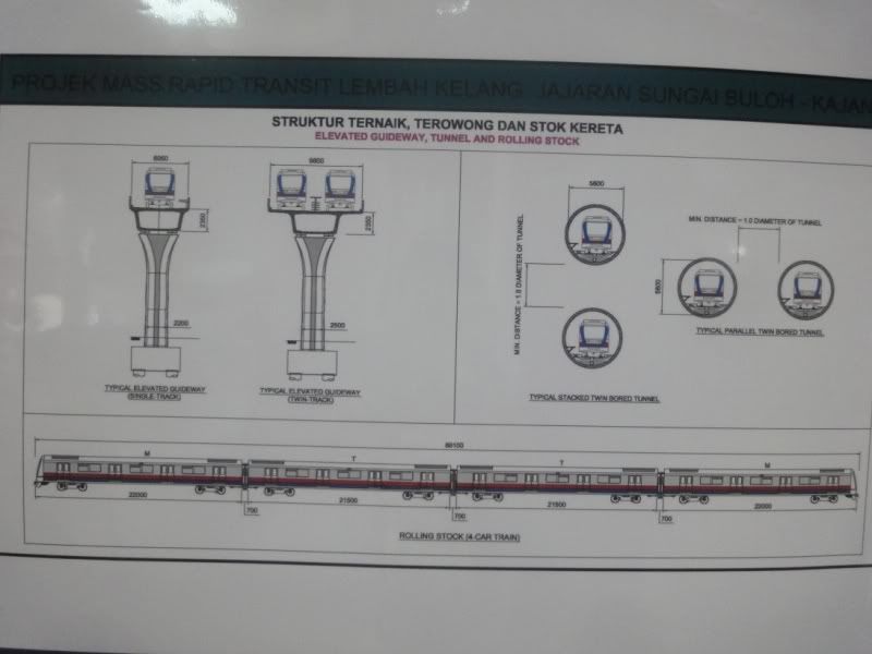
Dimensions of Guideway Structure, Tunnels & Rolling Stock
The image below gives a good idea of dimensions for the MRT elevated guideway, tunnels (including tunnel structure) and the MRT train carriages themselves.

Click here for a larger version of the image above.
Car 1 : 22000 mm
Gangway : 700 mm
Car 2 : 21500 mm
Gangway : 700 mm
Car 3 : 21500 mm
Gangway : 700 mm
Car 4 : 22000 mm
Total train length : 89.1 m
Depot drawings (photos courtesy of vinann.com)
- Station – Elevated Side Platform;
- Station – Elevated Island Platform;
- Station – Underground Island Platform;
- Station – Underground Side Platform (Stacked);
- Station – Tunnel and Elevated Guideway (Typical Section);
- Station – Depot;
- Feeder Bus Routes;
- Plan & Profile;
- Road Widening.
Route Image

Click here for a larger version of the image above. Do note that all station locations & alignments are proposals only and must be approved by local councils, SPAD and the Minister of Transport (and presumably the Cabinet).
- Photos of Station drawings (photos courtesy of vinann.com)
- Official Station Drawings (Station 1-35) – courtesy of kvmrt.com.my
- Station drawings have also been posted to Skyscrapercity.com here, here, and here.
- NEW: See videos of impressions of the future MRT stations here.
Alignment
Check out this graphic drawn up by The Star, which shows the proposed MRT Line 1 & 2 in comparison with the existing railway system. Do note that the projected LRT extensions are not included. TRANSIT does not know why they were left out.
Click here for a larger version of the image below.

Click here for information about the Alignment Map which shows the Local Councils involved in the Sg. Buloh – Kajang MRT project. The video below follows the proposed alignment from Sg. Buloh to Kajang.
You can also see the original video posted by KVMRT, at this link. There are already comments from viewers.
Land Acquisition Plan
Quoted from kvmrt.com.my:
The lots marked here are those which were identified pursuant to Section 4 of the Land Acquisition Act 1960 where the public has been notified of the general land area which has been gazetted for POSSIBLE acquisition. The exact plots of land which will be acquired can only be determined and confirmed only after public feedback has been received and when the alignment of the MRT is finalized.
TRANSIT Says:
When we first read the announcement of public notice in 10 February, we could not help but notice that it was placed right next to a political column (as opposed to another ad or different article).
There is a term called “juxtaposition” which describes the attempt to gain attention or influence by the placement of ideas together in certain ways. It is commonly found in newspapers and the media in general. The notice, placed opposite a comment extolling the virtues of the Najib Government (ok, supposedly the article is about what Najib needs to do to win the elections – ok look at the MRT notice just to the right of the article), is a fine example of juxtaposition – the notice placed “just so” becomes an example of what the PM has accomplished, which is part of his election formula.
And here we were wondering why Idris Jala and Pemandu were in such a rush to drive home the message about the MRT network!
But juxtaposition & use of the media is not a terrible thing – as long as one’s motives are honest & positive. As Pemandu have said themselves, some people like the MRT, some people don’t but we have to have the MRT in the Klang Valley.
Anyways, TRANSIT invites you to comment and give as much feedback on the public display as possible – so the debate & Public Consultation about the MRT can be handled in the proper way – in the interests of the Rakyat.
Comments on the Alignment
Please note that our comments will be updated regularly, so check back as often as you can
General
- The Satellite Image is described on the kvmrt.com.my website as “MRTB(Opt),” perhaps meaning Option B. If this is the case, TRANSIT would like to know, where are Option A, Option C (if there is one), etc.;
- Petaling Jaya residents are now talking about re-routing the Sg. Buloh – Kajang MRT through Petaling Jaya. However, extending MRT Line 2 (The Circle Line) through Petaling Jaya may be a better option.
Segment in MBPJ
- The line will follow the Persiaran Surian alignment through Kota Damansara to Bdr. Utama;
- There will be some tunneling in this area;
- The “1 Utama” station will be located on the LDP, just south of the Bandar Utama-TTDI interchange (Lebuh Bandar Utama-Jalan Burhanuddin Helmi) as seen here;
- There is a suggestion that the 1Utama station be moved further north to align closer to the 1Utama New Wing and Bus Terminal, as seen here.
Segment in KL
- The proposed TTDI Station is located along Jalan Damansara near the TTDI market.
- Bukit Bandaraya residents are calling for the MRT to run underground.
- It is quite clear that the Sg. Buloh- Kajang MRT line will not be going through NU Sentral along Jalan Tun Sambanthan in Brickfields. Instead, it will pass the north-west side of the KL Sentral complex – meaning some manner of walk to the main rail station will be necessary – just like it is with the KL Monorail!’ See an aerial photo of the site here. Please note that the station alignment actually follows the road.
- There is a possibility that the MRT Line 2 (Circle Line) will run past KL Sentral’s NU Sentral development (actually under Jalan Tun Sambanthan in Brickfields) – however this routing has yet to be confirmed by SPAD.
- The MRT will also be some distance from Kuala Lumpur Railway station but the location of the Pasar Seni MRT station (which will be the interchange) is connected to the Pasar Seni LRT station complex as seen here.
- Instead of tunneling along the Lebuhraya, SPAD & Prasarana should consider tunneling under Jalan Parlimen and Jalan Tun Perak – providing a station at Dataran Merdeka with an underground link to Masjid Jamek – and both the Kelana Jaya & Ampang LRT lines.
- The MRT could then continue along Jalan Tun Perak under the Ampang LRT line to Plaza Rakyat & Puduraya, linking the MRT to the main bus station. After this, the MRT could follow Jalan Bukit Bintang.
- Alternatively, the MRT could follow Jalan Raja Chulan to Jalan Bukit Bintang.
- We would like to know what the rationale is for Station Merdeka (presumably near Stadium Merdeka) which does not appear to be located near any main road, hence access to nearby areas would be limited.
Segment in Cheras
- There are concerns about the location of Bandar Tun Hussein Onn station.
Segment in Kajang
- The station at Bandar Kajang will require the destruction of a number of shophouses, which will be replaced with an elevated parking garage as seen here. The area under the station will be landscaped and made into a parkette. An aerial photo of the site can be seen here. Please note that the station should be shifted about 10m further north.
- The north entrance/exit to Bandar Kajang station is located right in front of the Bangunan Dato’ Nazir, the site of the famous Satay Kajang. Maybe that is why the MRT needed to go all the way to Kajang?
Updates on the proposed alignment
Please note that these updates are as of the launching of the MRT on 8 July 2011. Direct links to photos will be provided as soon as possible.
MRT Line 1 | Sg. Buloh to Kajang | Mid 2011-Late 2016
We have learned that:
- There will be 31 stations with provision for 3 more stations (total of 34);
- Seksyen 17 & Seksyen 16 Stations have been combined into one station at Sekysen 16;
- TTDI station has been moved southwards from the original proposed site to a site between the Caltex petrol station and Jalan Wan Kadir 4;
- A station at the Rubber Research Institute will be provided in the future;
- Bukit Bintang station will be shifted to the west side of Jalan Sultan Ismail for faster access to the KL Monorail and will now be called Bukit Bintang Central; [TRANSIT: Why not just call it Bukit Bintang?]
- “KL Sentral” will actually be built on the site of Muzium Negara; [TRANSIT: So call it Muzium Negara]
- It appears that Plaza Phoenix, Leisure Mall, 1Utama and The Curve still get their free advertising; [TRANSIT: And yet they talk about maximizing revenue]
- There will be 16 stations with Park & Ride facilities as opposed to 13 proposed originally;
- The alignments of Sg. Buloh & Kajang stations have been adjusted
As always, your comments and feedback are welcome … and in this case, necessary so we can get the best MRT!
TRANSIT will continue to update & comment on the public display but right now, we need your feedback. Please comment in the space below and do not forget to send your comments to SPAD using their comment form, or through email feedback@kvmrt.com.my or phone 1800 82 6868

63 replies on “MRT Update: Sg. Buloh – Kajang Line – Public Display, Planning & Construction (Update #33)”
hey transit will you be there?
Hi @Dave
We hope to have a few people there. Please come along and bring a few friends.
Regards, Moaz for TRANSIT
The technical specs simply read like a PR copy from the LRT extensions albeit with less info. Trust them to put down the 100kmh max speed without laughing. To say that there will be “future integration with other modes of transport” sounds like they are not even trying to achieve that with this one, and it shows in the crude alignment map.
Hi @Ethan
We certainly hope that SPAD will improve on their communication of information as part of the public display. After all, they should have learned from the last public display in September-November 2009 for the LRT line extensions.
Since the public display has not yet started, please send them your feedback and there might be time to get some changes done in the first few weeks.
Regards, Moaz for TRANSIT
Good to see it first here. Save from being at MidValley tomorrow.
Overall the alignment is ‘good’ when taking costs into balance. This is achieve by building 80% elevated along trunk road. Being ambitious, we could have 40% underground route and stations located right at the center of each township with excellence feeder support! From the satellite image, it is evidence 5-6 stations located in this line are single-sided support (either left or right) where the other side either being a golf club, rubber estate or undeveloped areas.
Since underground start after Semantan station, why not build it under Bukit Persekutuan and Bangsar (instead of under Mahameru h/w & Jln D’sara)? We could have underground station at Bangsar Maarof and turn nicely into KL Sentral bridging the missing monorail link.
However, the route from KL to Kajang is excellence using some portion of inner minor road instead.
Integration? Arrrrrgghh… Only one central interchange?? Not linking the monorail?? Even KL Sentral is amiss and off target?? No easy interchange with central KTM station? What an awry design..
OK, from my opinion, the best central interchange is still Masjid Jamek. Doing it at Pasar Seni will push passengers between Masjid Jamek to Pasar Seni stretch far beyond capacity limit. It seems the Sentul bound commuters are not really welcome in this new line.
I also notice the Pasar Seni station proposed, located further up to Pudu where it is better to build underneath Klang river, act as underground pedestrian with KTMB trains. Maybe they thought linking Sg Buloh & Kajang KTM stations have already solved the equation, which probably not accurate.
Verdict : Good for a line long needed but fine tuning is the best thing to do.
@Azmi
Thanks very much for the feedback. Don’t forget to send your feedback through the online feedback form, through email feedback@kvmrt.com.my or written feedback at one of the Public Display sites.
Regarding the routing through Pusat Bandar Damansara instead of Bangsar, that is probably based on the need for a public transport alternative through Pusat Bandar Damansara and the Jalan Semantan buildings (which house offices, hospitals, government offices and a college or two), and the likelihood that they would prefer the lower cost cut & cover alternative which would be far easier to do using the route they have chosen.
A line through Bangsar would have to be fully tunneled, and it is likely that the residents would object strongly to tunneling. On the other hand, it is also quite possible that Bangsar will be getting a monorail or be served through MRT Line 2 (Circle Line).
As for the routing along the Lebuhraya towards KL Sentral, we would be happier to see the line be tunneled under Jalan Parlimen and Jalan Tun Perak, basically following the Ampang LRT route until Jalan Bukit Bintang, then continuing along the route as proposed.
This would allow a station at Dataran Merdeka (with fare-paid tunnel & above ground walkway links to Masjid Jamek), as well as an MRT station at Plaza Rakyat / Puduraya (since this is the site of the main urban bus terminal in KL).
The station at Stadium Merdeka really doesn’t make much sense. Similarly, the location of the station at KL Sentral and routing along the Lebuhraya appears to be poorly planned.
Regards, Moaz for TRANSIT
[…] proposed MRT network for the Klang Valley, including the public display for MRT Line 1, MRT Line 2 and MRT Line 3; [TRANSIT: Please note that all updates on the MRT are tagged with the […]
Thanks Moaz for your suggestion. Hopefully I could send the formal comments to SPAD email address given on return from Singapore this Thursday. Wish Transit do the same.
Yup. We are on the same page about Stadium Merdeka station. Although government has odd plan for Warisan Merdeka but it could end up like another Plaza Rakyat station should something out of the blue happened (another war erupt, another financial crisis, change of gomen, another bankruptcy etc ). The rest of the stations in KL are good but they definitely missed one of the ready available, most crucial area, which is Jalan Raja Chulan and I have no idea how on earth they could have forget this. Haste makes waste. Maybe stations in Bukit Chulan will be on MRT Line 2 or Line 3… I do not know. Is very important all the interchange stations and stations in KL city centre been draw in holistic manner so we are not talking in the dark like this.
I also agreed tunneling under Jalan Parlimen and Jalan Tun Perak is the better option – providing a station at Dataran Merdeka with an underground link to Masjid Jamek.
@Azmi
Thanks for the response. We believe that the Warisan Merdeka (if built) would be better served by good connections (above & underground) to multiple rail stations rather than having a single station at the base or near the base of the tower. And we are quite concerned about the lack of connection to Puduraya-Plaza Rakyat which is likely to be the site of our stage bus holding area & terminal (how can an integrated transport network miss out on the bus system) – as well as the lack of service to the commercial areas of Jalan Raja Chulan.
Please send your comments to SPAD using their comment form, or through email feedback@kvmrt.com.my or phone 1800 82 6868
Regards, Moaz for TRANSIT
I request a park and ride for Balakong station. Nonsensical to not have one at my place. Without the park and ride taking the MRT is going to be such a hassle.
@Fong
Please send your comments to SPAD using their comment form, or through email feedback@kvmrt.com.my or phone 1800 82 6868
Regards, Moaz for TRANSIT
having read their specs
hmm, i must say 4 coaches is a bit too short and having looked at their concept drawing of stations there seem to be insufficient platform length for expansion. (BTW the concept drawing were made with google sketch up and they were using the Simens Velaro models for their trains!)
Also, They should have extra sliding and platforms to introduce special services. This can reduce travel time as not everybody enjoys a train that stops at every @ppl3s station.
@Kitty
Thanks for the feedback.
Regards, Moaz for TRANSIT
for those curious as to where the peeps at KVMRT got their pics, look not further then wikipedia!
[…] As you can imagine, this will take some time so please check back to this post and the post on the MRT public display regularly. Announcement for MRT Open Day, 13 February 2011 at MidValley Convention […]
Proposed Station Bandar Tun Hussien Onn
I am a resident of Tmn Megah Cheras and I am familiar with the area around the proposed station.
The propose site is not suitable because it is not near housing area (reasonable walking distance). Plus it is next to the intersection of Cheras Highway and road to BTHO – imaging the major traffic disruption to Cheras Highway during peak hours when cars going in/out of station.
The section after Tmn Cuepacs to Kajang does not have major catchment. Why not align to BTHO town centre, Jusco Selatan, C180, Columbia Hospital, Cheras Jaya Industrial area. These areas have high traffic as compared to the proposed alignment. It may cost less to align along the highway but if it is not easy accessible and in low traffic area, what is the point?
1. Were 4-car trains chosen because it’s cheaper?
2. Reasons must be sought as to why interchanges are not proposed with Komuter in Pasar Seni and monorail in Bt Bintang. Looks too much like another cost-cutting measures.
3. The maths doesn’t seem quite right:
i) If they were to have a 109sec service headway across the 90-min route, 50 train sets per direction at one time would be needed, yet only 58 train sets would be purchased.
ii) To carry 30,000 people per hour per direction with 4-car trains of 1,200 capacity each, it would require 25 trains an hour or one every 2.4mins. Assuming 58 trains would result in 29 trains or 34,800 people per direction. This is spread over the 90mins needed to cover the route, so one hour would only be 23,300 people.
4. The idea of exploiting land value around stations seems to be focused at pushing for the pet projects of Warisan Merdeka, KLIFD and RRIM, rather than strengthening the suburban town centres. It’s more about benefits to the developers instead of the common folk.
5. The feeder bus system doesn’t look any different from the failed feeders of ex-STAR and PUTRA lines. Prasarana has a whole KL bus network under its control yet they’re not making efficient use of it? Why propose a discarded system?
Four coaches mrt train??? I don’t think it is good enough to handle large and increasing population in the future. No mrt train in the world is four coaches only.
as what I can see here, the stations located at “orang2 kaya saja” area.
well, as I can see, the area of “mat rempit, proton saga megavalve, kancil area” still need fill up ron95 and burn carbon and facing massive traffic jams everyday.
If there’s existing Komuter Station, but where’s feeder bus?
@Mohammad Suhaimi
you’re doing yourself a big disfavor by opting for KTM now
sardine packed trains till at least end of 2011 but then they definitely want to do their “safety testing” expect some where around early 2012. But by then, more KTM EMUs would have broken down, and you would be in the same boat as it is now.
@Sam
I have no choice. At my place, rapid KL bus is hopeless
nearest Komuter station, about 1.5km, if take taxi, cost me rm5 non metered charges. Parking? rm2 per day, but end-up your windscreen smash and lost ur car component. Parking motorbike is free, and only tyre trace left.
Mohammad Suhaimi,
i juz love your comments. while it is funny, it is not further from the truths. rapidkl can’t even optimise their bus networks, yet they (prasarana) are undertaking yet another mega project, KVMRT. Good luck with it.
The MRT should have sufficiently long platforms for longer trains and they should consider investing in automatic doors, Singapore is upgrading their stations and we should look to Singapore for help.
I have studied the proposed stations in Kajang
1) Jalan Bukit (Intergration with KTM)
2) Jalan Besar (around stadium area)
3)Saujana impian.
The three statiions are too close to each other and mostly benefit those people living Kajang town area and saujana impian unless there will be superb bus services & interconnectivity to other areas. Saujana Impian is considered ‘orang kaya area’ so not really benefitting the financially challenged people.
It is most disappointing that there aren’t any station near to Jalan Reko (towards Bangi side). If there is a MRT station around the Jalan Reko area, more people will have easy access to MRT. The main bus station is Hentian Kajang at Jalan Reko.A Jln Reko MRT Station will have the catchment of those people living/working in Bangi, UKM, Bandar Teknologi, Taman Tenaga, Taman Sahabat, Reko Sentral, Alamsari, Tmn Universiti, Kajang 2, Kajang Hill Park,Natayu Tmn Bukit Mewah, Tmn Harmoni . There are loads more people living & working & studying at these areas compared to Saujana Impian & Kajang town.
Kajang 2 & Hill Park are new development by Metrokajang between Jalan Reko & Bandar Teknologi. Nadayu is also a new Taman coming up around Kajang 2 area.
Intergration with komuter should be easy at Jalan Reko as there is the UKM komuter station and railway track all along it. I heard that KTM has requested land at kajang 2 from metrokajang for proposed new station to replace one of the komuter stations. Perhaps SPAD can approach the same developer (Metrokajang) and KTM and see if something can be worked out. There are loads of empty land that area along the komuter line.
I use public transport (meaning bus) quite often and I can assure you that the bus service in Bangi, kajang and bandar teknologi, taman harmoni area is pathetic and almost nonexistence. Most of the ‘Tamans’ are not service by bus services and taxi drivers here never use meters. There is infact only 1 bus service route covering Bangi : Jalan Reko (Hentian Kajang) – UKM -Seksyen 16 Bangi. And the condition of the buses are terrible (remember the pink minibuses long time ago in KL? The mini buses here are 10times worse than that. Sometimes driven by indonesian driver! Is that legal?)
I wonder who plans & decides & governs bus routes/services in Bangi/Kajang/ Bandar Teknologi/ Semenyih???
If MRT is to remain in Kajang Town/ Jalan Bukit & Saujana Impian, SPAD please… please.. please… make sure there are bus services/feeder buses with routes covering all sections of Bangi, Bandar Teknologi, Kajang Hill park, Taman Harmoni, Otherwise people will just drive their own cars / motorcycles to their destinations instead of using the MRT (I will be one of them if no bus connectivity)
Can SPAD please publish the propose feeder bus routes to mrt stations so the the public can see the overall connectivity?
@ Dazzle
Is good to have MRT stations close to each other at highly density areas as Kajang so more people benefit easy access & spreading the congestion and car parking facilities evenly. Remember, this is mass rapid transit not an inter city transit.
I would agree another Jalan Reko station is great to have supporting all your mentioned Taman’s, Bangi & UKM. The exact location will be at Reko Sentral bus station. However, this is south of Kajang KTM station and require additional 1km extension from the proposed MRT end stop at Kajang KTM. But, end’s line station does not necessary to be an interchange, isn’t? Altenatively, KTMB should build another station just adjacent to bus station in Jalan Reko or near to Persiaran Bangi junction.
3 nice spots for mrt stations in kajang would be at
1) Saujana impian or Tmn Mesra (Not both…got short cut road from saujana impian which can exit to tmn mesra )
2) Kajang (either bandar kajang or Jalan Bukit ; not both because within they are too near to each other)
3) Jln Reko
kajang town is congested everywhere.No more space to even spread the congestion/ car parking facilities . Besides Kajang town isn’t so big,
I can walk from one end to the other.
I thought the aim is to get people from outside to use MRT instead of using cars to go to town / city center. If the stations are all in town/city, people still drive in and add to the congestion.
It seems here we have to go to city/town to use MRT to reach another city/town??
MRT is such an expensive project, I think the goverment should not rush through it without proper planning and taking account of future developments/ suitability of station sites and coordination with other modes of public transportation.
So long as the feeder buses provide high connectivity & excellent service to the other areas/Tamans I have no compaints. Bus services and connectivity is my major grouse.
@ Ethan
I like the ‘maths’. There is something wrong with their ‘Operation Management’ studies on man-movement, capacity, bottleneck, forecast schedule, avg speed and the quantity of trains to be issue in the Purchase Order!
The idea of exploiting land value around stations as off-target KL Sentral, Warisan Merdeka, KLIFD and RRIM, rather than strengthening the suburban town & existing commercial centers are so sad to say. Probably they learnt so much from the HK MTR. Instead of visioning to provide the most efficient, reachable, user-friendly mass rapid system they are blurred with ‘business are everywhere as usual’. What best in HK does not mean the best to KLV/GKL.
No interchange with KTMB city center, monorail, KL Sentral (bluffing in the name of KL Sentral) are their ‘tentative cost-down’ at the expenses of rakyat and good public transport system. Lesson never learnt!
I am downgrading from ‘HOLD’ to ‘SELL’ on this line. Something must be done before it is too late!!
Dear Transit,
Due to the unavailability of technical information in their website, I was wondering if our underground stations for the proposed line have multiple entrance like MTR in hong kong or it would have only one or two entrances?
I would suggest that the underground stations, or even elevanted stations have multiple entrances from all directions, for example station near pavilion, to have entrance from the mall itself, entrance at chulan square, as well as entrance from farenheit 88. Would that be viable?
Hi @Marc
Thanks for the comment. We expect multiple entrances for the underground stations as well, but we do not know until we check out the actual plans for each and every station.
Regards, Moaz for TRANSIT
Hey Transit,
Could you go to where vinann got those drawings and scan them in high definition so that we may further scrutinize those drawings.
Even better yet, could you email spad or whoever that operates the kvmrt website to upload it so that we may all inspect it for the greater good.
thanks
you’re the best
ps please upload those pics here, thanks
Hi Sam
We’ve actually asked SPAD for the drawings – we will have to repeat our request.
Regards, moaz for TRANSIT
based on the depot drawings, the train will be no longer than 100m and that means the max length of the MRT will be no longer than 4 coaches!
This is just sad!
the rolling stock for this kvmrt really look alike bombardier movia metro. bombardier supplies this 4 doors each 4-car train train for delhi metro. check this out! it is movia metro! ;-D
http://www.bombardier.com/en/transportation/products-services/rail-vehicles/metros/delhi–india
@empatpuluh
Thanks very much for the link & video.
Regards, Moaz for TRANSIT
@Sam,
You can see a good close-up of the proposed KL Sentral MRT interchange from image in the Malaysian Insider article at :
http://www.themalaysianinsider.com/malaysia/article/eyebrows-raised-over-mrt-integration-locations/
Why mainstream media never concern about this missing connectivity?
@Azmi
”
Why mainstream media never concern about this missing connectivity?
”
I think you should take the initiative and email this to the editor and certain journalists of all the major papers.
We can’t expect them to know everything. Anyways, I shall note the point that most media staff are probably car users so they could possibly be out of touch with our interests.
@ transit
“but we do not know until we check out the actual plans for each and every station.”
so please make spad or whoever scan it and upload it so that we may check it give really detailed feedback.
@ empatpuluh
Woow. They will use 4-doors train?? (x 4 car = 16 doors total). The carriage will be absolutely longer, wider & bigger. Let’s compare the carriage total length with the station platform length (later, when we see the station floor plan). Then we could figure if they will start at full rolling stock capacity or not. Great video!
@ SPAD
Additional comment. Since there are plenty access/exit point (doors), hopefully you can reduce the ‘Average Dwell Time’ (Purata Masa Berhenti) from 20secs to 15-17 secs. We do not need the doors to open so long when jobs already done. Doors closing alarm and intrusion auto-retreat must come as standard though.
Go to hit maximum speed 100km/h (even for 3 secs) when distance between station >1.2km. Buy good train specs. Use good ‘cant rail specs’ [ http://en.wikipedia.org/wiki/Cant_(rail) ] and etc etc.
Above all, we just want faster / shorter travelling time by increasing the ‘Average Speed’ from the poor 35km/hr to 50km/hr just like other developed countries MRT. Singapore MTR has 45km/hr avg speed. ;-(
@Azmi
Yup they should get trains that work like the English HSR. I hear it can bank at really high speeds!
This is a good place to feedback on MRT. Other blogs & media comment page only full of criticizing, complaints, polititics etc without offering any solutions, but here are a bunch of people with intellectual ideas. Congralate!
@Hasan
Thank you for the positive feedback. TRANSIT appreciates your support, invites your continued comments, and hopes that you will tell all your friends.
Regards, Moaz for TRANSIT
Obvious ownage!
http://www.cahighspeedrail.ca.gov/
Owns
http://kvmrt.com.my/
Also
http://www.cahighspeedrail.ca.gov/getinvolved.aspx
why can’t we get as involved as this?
@Bob Dylan
We can get this involved, but our laws do not really allow for or encourage this kind of public consultation.
That, combined with weak laws, a “top-down” planning approach and a “government knows best” attitude (which still exists despite reports to the contrary), as well as politically-inspired deadlines and … er…other factors, as well as the general impatience and wariness of the general public, makes it tough for real public consultation to take place.
Which is too bad, really – because if the planning approach really involved public consultation, a lot of the issues could be resolved without much resistance.
Of course, we at TRANSIT are doing what we can, and we encourage the public to get involved and give the feedback that the government, SPAD and Pemandu need (and have earned for themselves).
Regards, Moaz for TRANSIT
I think we need more data from kvmrt.com.my the stuff they put up there is insufficient!
hey transit
can you upload the station and depot drawings here? I don’t think that many readers realize that you have posted a link.
Hi @Bob Dylan
If you are referring to the images posted by VinAnn, those are the property of that blogger and we would have to ask for permission first.
We will of course try to get the images, either from VinAnn, our own sources or from SPAD directly. We do agree that the information on the kvmrt.com.my website is insufficient – but unfortunately, the presence of the website is actually exceeding the requirements of the Railways Act.
Regards, Moaz for TRANSIT
I’ve a question.
According to the pictures taken, are there only going to be 4 coaches for the MRT?
Hi @Tim
Yes, from the information that we have the trains will be 4-carriage consists. However, the length and width of each carriage will be closer to “MRT” standards.
We do not have any information on platform lengths or if there are any plans for longer trains (for example, 2 individual 4-carriage trains coupled together).
Regards, Moaz for TRANSIT
I hope parliament will draft a bill such that the MRT may be able to be built under people’s property, and not follow under some river, just like the Kelana Jaya line.
@transit
are they going to have platform screen doors for the elevated section?
hi @Bob Dylan
We certainly need some improvement and an MRT or Urban Transport Law would be very helpful.
To get started though, we need to get SPAD to re-organize from the existing “Rail”, “Road”, “Tourism” and “Freight” divisions to create “Urban Transport” and “Interurban Transport” divisions (as well as tourism & freight).
This would create a greater focus on urban transport (stage buses, short-distance express buses, LRT/MRT and Commuter Rail) as well as inter-urban transport (express buses, intercity rail, long distance commuter rail)
We do not expect Platform Screen Doors (PSD) for the elevated section. However, it might be possible that railings or half-height screens could be introduced.
Given the problems that RapidKL have had with track intrusion (mostly on the Kelana Jaya line but that is the line which has the intrusion sensors), some kind of platform barrier for the elevated stations is going to have to be considered.
Regards, Moaz for TRANSIT.
It seems unlikely than an operating train can be more than four carriages. From the technical drawings, the station length is apparently about 125m; minus the plant rooms at both ends of the platform, you’ll only get enough space to fit the 89.1m train.
The proposed travelators underneath Jln Bkt Bintang is interesting but the underground link doesn’t seem to be planned as a “paid area” for transfer to the monorail station.
It is apparent that retail lots for passenger convenience are not designed into the stations, so stand-alone stalls blocking the way would likely have a continuing presence in these concourses.
Having shops and the concourse at ground level (where appropriate) would have better integrated a station with its surroundings.
which one is the correct route the star refer to circle line?
http://biz.thestar.com.my/news/story.asp?sec=business&file=/2011/1/31/business/7885702
Source:LPTC & DBS Research
http://biz.thestar.com.my/news/story.asp?file=/2011/3/5/business/8194029
Source:Khong & Jaafar
Well, we truly do not know which one is more accurate/closer to the real thing.
But we do know that the first map is not well done (look at the scale & integration of the KL monorail) and the second one has better, more accurate scale and is more recent.
Regards, Moaz for TRANSIT
I shall just leave this here.
Click to access GMDB0064_Pre-Q-Ad_Eng-3.pdf
In case anyone is wondering, the link from Bob Dylan is the Request for Pre-Qualification for the Sg. Buloh – Kajang MRT project.
Regards, Moaz for TRANSIT
[…] Display for MRT Line 1, (MRT Line 2 & MRT Line 3 coming […]
Let me devote a time for public transportation, specifically on the MRT Circle line based on the graphic from the Star, as attached above. Since there is no dedicated section on ‘Circle Line’ yet, I write at the ‘normal’ MRT discussion (which is already so long, but Transit can shift it to wherever appropriate).
The official public display has yet to take place but sure it was not draw out just as a sketch. There are good reasons it was toss together with other network and not being a nice exponential circle also mean there is real senses as well as good signs for the line to be well-connected and covered carefully.
The Star’s graphic was magnified many times then superimposed onto KL Google maps and the result was remarkable. Allow me to imagine the tentative details.. The assumption of stations location is based on the location of popular demand (hot-spot) and critical thinking (strategic spot). This method is just opposite to child’s play – ‘draw by connecting the dot’.
Let start anti-clockwise from Pusat Bdr D’sara station, (well.. we can start anywhere actually…) interchange with the Sg Buluh-Kajang line. From PBD station, this underground section move under Bukit/Taman Bandaraya with two underground stations, one in residential Jalan Maarof/Ara Utara and another underneath roundabout near Jalan Tempinis/Cenderai/Riong commercial areas. It will continue south-bound and interchange with the much underutilize Abdullah Hukum LRT station. Then it will proceed to interchange with KTMB’s Seputeh station. On the way to KL Sentral, a P&R station could be build, accessing from Jalan Syed Putra probably near the Macoba/Wisma Belia building acting as dispersal station outskirt of city center. Next station is KL Sentral, nearby Nu Sentral linking the missing link (still underground). It moves onward with a station at Kg Attap which home/HQ to various 2nd tier bank. It could also act as walking interchange with Maharajalela monorail. Then, train continue moving underground approx. along Jalan Istana towards Sg Besi with one or two stations for the new RMAF 1MDB hub.
As can be seen, the advantage of going underground are enormous as alignment construction and stations location can be draw anywhere in the best and majority interests.
The alignment move east-bound crossing SMART highway before arising above the ground and merge with the AMPANG LRT line. A good rationale in minimizing costs by utilizing existing Ampang line track/gauge. (this stretch itself, is quarter-circle anyway). With the Circle MRT line merging the existing LRT line, I am not sure either the branch line will be convert to linear line for 2 separate line (LRT Puchong extension + MRT Circle line) with a new interchange station?
From the end Ampang station, the line will extend towards Ampang Jaya, with one good station along Jalan Kerja Ayer Lama (near the international school). The line continues with another station near the busy multiple-flyover/junction near the Flamingo Hotel, off MRR2. It will move forward along Kampung Berembang (maybe one station here) before crossing Klang river & Ampang elevated highway with another station at the end of Jalan Enggang industrial area. It move forward to interchange with Setiawangsa station of Kelana Jaya LRT line. Another good and very busy interchange station. Currently many residents along Ampang LRT line that worked (shopped etc) at KLCC hinder LRT next-door because it will take them ‘around the world’ before reaching nearby destination and also expensive (fare).
Now, the train move north-west to the vast and highly populated catchment of Desa Tun Hussein Onn, Setapak Jaya, low cost DBKL flats, Jln Genting Kelang and Danau Kota/Taman Setapak with individual station in each area. Total 5 stations.
The train now move south-west with next station interchanging with KTMB Sentul station (Batu Cave line), nearby Kelab Golf Sentul Raya. Oppss.. unfortunately, it seems the Sentul LRT station is not connected as evidence from the image that was off-distance with the MRT Circle line alignment. Unless the Sentul LRT is extended northward to Taman Sentul Utama and link-up, the northern commuters of Circle line will have unpleasant journey entering KL, enduring bottleneck and imbalance service quality changing train from & to KTMB. Furthermore, authorities have no plan integrate ticketing with KTMB besides those under Prasarana’s belt.
Moving forward, a much anticipate station in north of KL city center at Jalan Ipoh / Tmn Million, before going back underground and reaching another important interchange station at KTM Segambut, which cater all the north-bound trains from Rawang / Ipoh. Next, another possible station at the Kompleks Kerajaan or Dutamas Raya. Than we have a station at Mount Kiara and another station at Taman Sri Hartamas before the line turn underneath the hill of D’sara Height (not sure Damansara Height need a station? But if necessary, it would have long deep escalators, akin to London’s Angel station). Finally, it will complete it circular cycle at Pusat Bdr D’sara.
I can say this is a great line successfully linking all important populated township and put other separate line in good connection. Congratulate!
MRT FAQ
http://kvmrt.com.my/w/?page_id=928
[…] our feedback for the Public Display for MRT Line 1 (Sg. Buloh to Kajang). Please send your comments to SPAD using their comment form, or through email […]
[…] our feedback for the Public Display for MRT Line 1 (Sg. Buloh to Kajang). Please send your comments to SPAD using their comment form, or through email […]
i oppose the location of the kajang station. while the location might look convenient the construction involves the demolition of a row of almost century old shops. thats a part kajang history that any sound minded malaysian should protect and preserve. bangunan dato nazir will be a better and probably cheaper solution. best if it’s in the old stadium location across the street. lest cost on demolition and no need to acquire a row of shops.
replacing these shops with a multi story carpark is akin to tearing down the shops at petaling street in kl. from an architect/town planner’s point of view the entire urban fabric in kajang will be distorted with this ugly multi story on its main street.
Yes, but when will the MRT line be extended or coming to Semenyih? Semenyih will be an upcoming and developing area in the outskirts of KL in the next 4 to 5 years with new major twonships coming up like SP Setia Eco Hills, SP Setia Emas, Pelangi Semenyih 2, Tiara East, Gallery@Kesuma Lakes, UEM Land, I&P, Gamuda and Naza TTDI acquistion of land over there….
And what more with the rumours of the new Jusco in the vicinity of somewhere in either Bandar Rinching, Pelangi Semenyih 2 or Naza TTDI Semenyih township there will be more demand for the MRT.
My suggestion is to extend the Kajang-Sungei Buloh line and build an overhead station in Semenyih town near the Semenyih Bus Station in Semenyih Sentral and another overhead in the empty area in between the 3 storey shop offices in Kesuma Lakes beside the Gallery@Kesuma Lakes project