![]()
LATEST NOTE: Since the MRT project is now part of the Economic Transformation Programme, we will continue to update information about the MRT project through our posting on the Economic Transformation Programme entitled ETP Analysis: The MRT Proposal.
- Updated with poll!
- Updated with additional drawings!
- Updated with articles!
Introduction
This posting may be one of the longest that we have made in recent years, but we feel that it is necessary to get all stakeholders to sit down and look at public transport in an holistic manner.
As such, TRANSIT needs your feedback on these rail proposals – that means, detailed observations, comments, ideas, etc. We want to break our records in terms of the number of people who view and comment on this page.
Also, we want you to tell your friends, neighbours, and wakil rakyat to visit this page and give their comments as well.
A note from TRANSIT
Over the past few years, a number of proposals have appeared suggesting rail networks for the Klang Valley. Of these various proposals, 4 of them stand out, either because of the level of detail, quality of the proposal, or general audacity of those making the proposals.
In this post, TRANSIT will examine the 4 “main” rail network proposals for the Klang Valley, which come from:
- Fikir Runding (2007) – original / our drawing (NEW!)
- DBKL (2008) – original / our drawing (Coming Soon!)
- Prasarana (2009) – original / our drawing (NEW!)
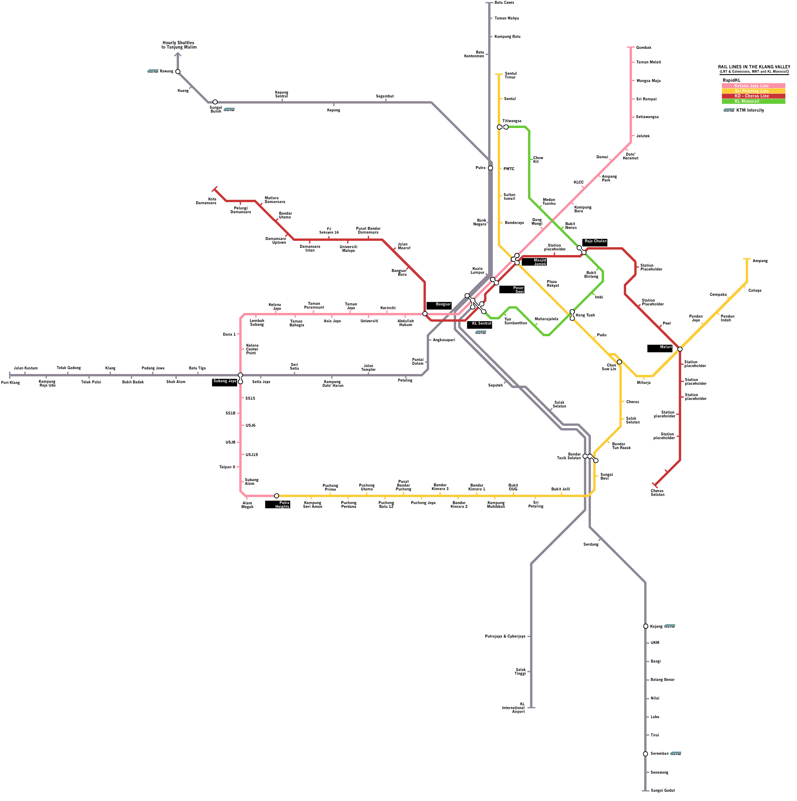
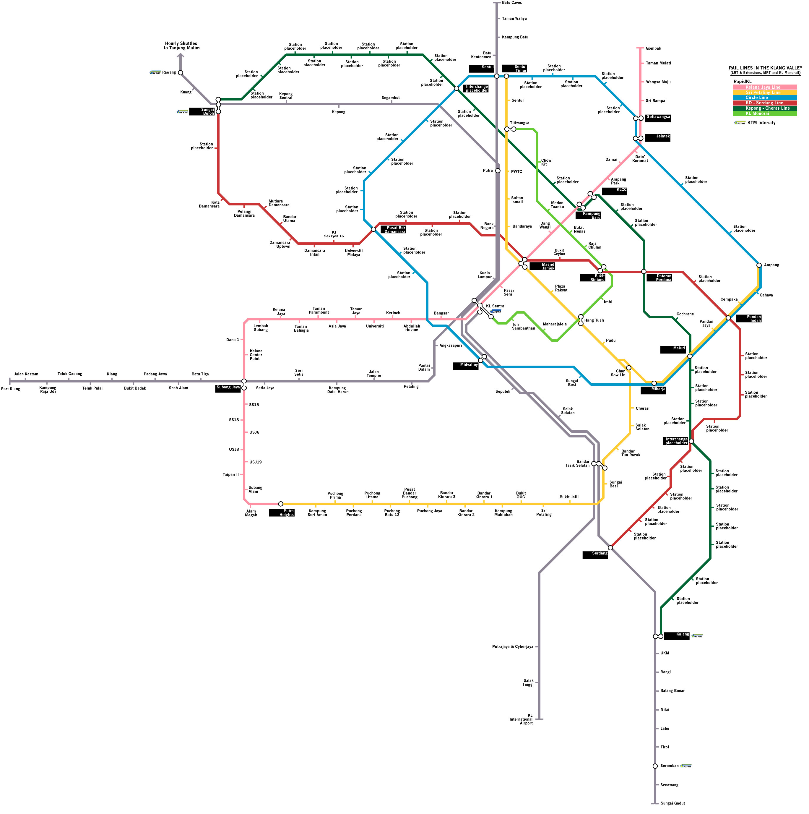
- MMC-Gamuda (2010) – our drawing / The Star / Malaysian Insider
You can click on the links above to see various versions of the different proposals. The slideshow & gallery of our drawings (courtesy of @Bukhrin) compares the various proposals.
Slideshow
Gallery


Our Goal
Our goal is to examine the proposals above in some detail, looking for similarities and differences. We will also look at the economic and financial justification (keeping in mind that there is very little information available) and examine everything through three lenses, namely:
- best practices in public transport investment
- best practices in transport-oriented development (TOD)
- cost-benefit analysis
Keep in mind that our resources are quite limited – but we believe that it is very important that the professional planners, engineers, and economists look at all of these proposals and come up with a real network solution.
Our intention with this post is to get the train rolling (as it were).
Details of the MMC-Gamuda Proposal
TRANSIT has been concerned with the recent announcement of an MRT network proposal for the Klang Valley, projected to cost between RM36-RM43 billion.

")

Our concerns are namely:
- That our existing public transport network is fragmented and that fixing the problems with existing service should be our priority;
- That the money invested should be spread out through the whole country;
- That there is no existing public transport service to act as a precedent to justify the cost of the MRT investment;
- That the last time we built rail services without having a public transport precedent, we ended up with 3 separate railway lines operated by 3 separate companies and built using 3 separate technologies;
- That all of the above railway lines had to be bailed out by the Federal Government;
- That the proposal (which comes courtesy of construction company MMC-Gamuda) was unsolicited and presented directly to the cabinet, rather than to any government agencies, workshops or think tanks or to the public;
- That the government has adopted the MRT proposal as part of the 10MP without consultation with other industry players, with SPAD or with the public;
- That the government has only now appointed consultants to conduct a feasibility study, after announcing the MRT proposal as part of the 10th Malaysia Plan, as can be seen from this article: 12 weeks to conduct MRT feasibility study (StarBiz);
- That the MMC-Gamuda proposal is the 4th proposal that we have seen for a public transport rail network (including Fikir Runding, DBKL, and Prasarana) and it seems that no one is examining the advantages and disadvantages of all proposals to come up with a final proposal
Knowing all of the above, you can imagine our skepticism and worry when we see reports of the proposal and letters from the unsuspecting public that suggest that the MRT is the solution to our public transport nightmare (as if the LRT worked so well). Examples of such comments & activities can be found at the following places:
- Gamuda hopeful KL MRT work can start next year (Malaysian Insider);
- MRT offers wider coverage (StarBiz)
We have similar concern over the other 3 proposals as well – as the reader can imagine, all of them have their advantages and disadvantages.
TRANSIT’s immediate goal is to present the details of each proposal, and examine the advantages and disadvantages.
In a future post, we will evaluate (as best we can) the proposals and give our recommendation for a future network.
The Key Details
Aside from the information that we have read in the media, TRANSIT notes that there are many “key details” of the MMC-Gamuda network proposal that we think are important and worth mentioning – and we will compare these details with the other 3 proposals.
A new perspective on “City Centre”
The proposal from MMC-Gamuda claims that the existing LRT lines do not serve the “City Centre” – which they have defined as the Golden Triangle, (KLCC, Bukit Bintang, Pudu, Pasarakyat) – and proposes that two of the new lines will interchange in this area.
[TRANSIT: The idea of serving the eastern side of KL, described as the “City Centre” in the proposal, is a good one, because it acknowledges that this area is high density and has a lot of potential for growth]
Northwest-Southeast Corridors
Both of the proposed MRT lines travel in a “northwest – southeast direction”, from Sg. Buloh to Cheras and Sg. Buloh to Serdang.
Similar corridors are also featured in the Fikir Runding proposal, DBKL proposal and Prasarana proposal. However, the MMC-Gamuda proposal has two lines, rather than one line.
[TRANSIT: Because of the consistent appearance of a northwest-southeast corridor in all of the plans above, we expect that at the very least, we will see the Kota Damansara – Cheras line (or a slight variation) built at some point within this decade. The most important thing is to identify the location of this line in the city centre and construct those segments, then move on to suburban extension.]
Multiple “Seamless” Interchanges
The proposal suggests that there is a need for additional interchanges between LRT and MRT stations in the Klang Valley and will plan the MRT lines to maximize the number of available interchanges.
The interchanges are also being described as “seamless” and designed in the same manner as interchanges in Hong Kong, Singapore and Kaohsiong.
Similar interchanges are proposed for the Fikir Runding, DBKL and Prasarana proposals, at different sites. For example, Prasarana proposes that KL Sentral stay as a main interchange, while the MMC-Gamuda and DBKL proposals seem to prefer Masjid Jamek.
[TRANSIT: Interchanges and network nodes are very important places in the network and having many interchanges will allow better flow of passenger movement throughout the network. In addition, the development potential for sites around interchanges is high – which can help to offset the cost of construction.
After having been exposed to the poorly designed interchanges in the existing rail network (particularly Kuala Lumpur-Pasar Seni and KL Sentral-KL Monorail) we do not think there would be objections to this.]
City Circle Line
The proposal includes a “City Circle Line” that will tie all of the LRT, MRT and monorail lines together. A similar line appears in the Fikir Runding proposal, while the DBKL proposal has multiple monorail lines that more or less surround the city centre and provide connections. There is no “circle line” proposed by Prasarana.
The main question about the city circle line would be its location – since the MRRI corridor – Jalan Tun Razak (formerly “Circular Road”) plus Lebuhraya Mahameru + Jalan Istana – could be used (it is included in the Fikir Runding proposal) but it is low density or already an engineering nightmare.
There is also a question of whether (or how) the line will serve communities surrounding the “city centre” namely older suburban areas like Bangsar, Sentul, Pudu and Ampang.
[TRANSIT: Having a “City Circle Line” is a nice idea but it is very unlikely that the line itself would be viable as a whole. Generally, circle lines tie together viable segments of radial lines and the whole is not always greater than the sum of its parts.
A good example would be Singapore’s City Circle Line – which is only 3 carriages in length (similar to the Ampang LRT) rather than the 6-carriages of a traditional MRT.
We need a clear understanding of the projected capacity of this circle line – and frankly, it may be better to have a few monorail lines instead of the one circle line.]
Underground construction
The proposal from MMC-Gamuda has a great deal of underground construction proposed for the two main lines along the “northwest-southeast” corridors. Most of the City Centre line would be elevated (except the western stretch).
This contrasts interestingly with the DBKL proposal (which consists mostly of elevated monorail lines) and the Prasarana proposal (which will only be underground from Brickfields to Bukit Bintang). We have no details about the Fikir Runding proposal.
[TRANSIT: As you can imagine, the cost of underground construction is quite a bit higher than the cost of elevated construction – and with MRT trains being wider than LRT trains, the cost will surely be higher. There is also the issue of the land under KL – which has many open caverns and underground rivers. It will be challenging to find proper corridors for tunneling.]
Building a Rail-Based “Backbone” and Increased transport demand
Each of the proposals recommends a rail-based public transport network based on the idea that it is the most efficient solution for our public transport needs. Rail has the advantage of being isolated from regular traffic and can therefore avoid traffic congestion.
The Fikir Runding, Prasarana and MMC-Gamuda proposals argue that MRT construction is justified and will lead to a high increase in public transport demand. The DBKL proposal seems to prefer monorail lines, but the emphasis is still on a rail-based network to move more people.
[TRANSIT: The advantages of a rail-based network are numerous and we do not argue against them. Our concern is that the cost of the rail network means that fewer areas can be served with public transport and that these areas must be mature, high density area.
Unfortunately, the recent trends in Malaysia have seen more of the population shifting to low-density areas, propelled by affordable private transportation.
Because the usage of public transport is so low, there is a huge gap between the existing number of public transport users and the anticipated numbers that are said to justify the construction of monorail, MRT or LRT.]
Rail good, bus bad
All of the proposals above are rail-based, and they mostly argue that the existing bus system cannot meet future public transport demand.
While the proposals (with the exception of Fikir Runding) do have varying degrees of bus usage incorporated in the design, it is clear that rail is in great favour.
The MMC-Gamuda proposal goes ahead to say that the SPAD proposal for bus lanes and BRT is unworkable because of congestion (shown in photos) on the existing roads where these routes have been proposed.
The MMC-Gamuda proposal takes a highly “selective” (biased) approach by using a photo of the TransMilenio BRT system in Bogota that suggests that the system will simply lead to more traffic congestion.
[TRANSIT: Selection examination of the details and all the options is nothing new. We at TRANSIT do it, so does the government and the public.
The key issue is what is behind that selective examination of the details. TRANSIT has got years of research and is aware of the best practices in public transport – and most importantly, our only stake in this is to see the best possible public transport system in the Klang Valley.
Can DBKL, Prasarana, Fikir Runding and MMC-Gamuda say that they do not have a huge financial stake in the future rail network for the Klang Valley?
That is why these proposals should be examined publicly, in an open and transparent manner – so that the ideas, thoughts, feeling and biases become clear and what emerges is the best possible choice.
It is also why we really prefer it that proposals do not come to the government from companies that have a direct interest in the proposal. ]
Benchmarking
The MMC-Gamuda proposal states that KL should have more MRT lines simply because other cities in Asia have more kilometres of MRT lines and we would not want the Klang Valley (or by extension, Malaysia) to be left out.
A similar argument is given in the other proposals – that having a longer, more complete network of rail-lines will give the Klang Valley significant economic advantages and improve quality of life.
[TRANSIT: Frankly, we do not buy arguments that compare “size” and “length” because the Klang Valley has a very different density pattern and public transport usage pattern as compared to many other cities in Asia.]
Feedback
TRANSIT needs your feedback on the above proposals – evaluating the advantages and disadvantages – and suggestions on what network would be best for the needs of the Klang Valley.
Thank you in advance for your feedback!

133 replies on “TRANSIT analyses the MRT proposal & compares it to other rail proposals (Update #5)”
[…] MRT Proposal for KL (first announcement, TRANSIT’s analysis) […]
well I just hope that eventually a good plan can be made and bring KL’s public transport to another level.
another country Malaysians can learn from is Japan, especially in Tokyo on how they can integrate both elevated rails and metro very well eventhough most are from different company by uniting the train ticketing system.
@CLF, Sam
Thanks for the feedback.
Regards, Moaz for TRANSIT
In my proposal that i found in reddit,there are atleast *5 lrt lines* proposed for the western klang valley and southern part of it…
They are :
Lrt 3 . Bndar utama -klang
Lrt 4 . Uiam – putra heights
Lrt 5. Kota kmuning – sg long
Lrt 6 . Bbk – sri hartamas via setia alam
Lrt 7. Mutiara bt raja – sg buloh ktm via kapar
Lrt 8 . Klang sentral – ktm rawang via puncak alam
Lrt 9 .ktm serendah to ktm nilai via coastal towns of selangor
Good Evening,
The ‘driving mentality’ of Malaysians will be here to stay knowing how our premises are form. For example our residential areas mainly consist of terrace houses and not highly risen. If one would have to drop off via bus at one end of the row of houses and intends to reach the destination at the other end, he or she would have wished to own a car. Unless the person has the pysch to be physically active, walking should be a pleasure, then (not under the always burning hot sun though). After all, we are lucky to have the privilege to be possible car owners anytime.
But nothing is impossible to encourage a public transport desirable public, right? And for those present public transport users, like I have said it is great pride to have the most advance transportation in sight but reaching one’s destination smoothly without long waiting time still remain the top priority now. So, I still give thumb ups for the suggested bus service planned on a large scale first. Thank you.
At Dr Mahathir’s website:
Dear Dr Mahathir,
How are you? I read that Dr Siti Hasmah said you are
not realizing your advancing age. Although you seemed to be looking alright to me via the press.
The letter I wrote you to be able to meet you is still valid. If you don’t mind, I would like to meet you to discuss the likely topics other than The Taman Bahagia Station as specified:
1) Chin Peng’s return, who is as elderly as you are.
2) Your trip to the former University Malaya in Singapore.
3) That the swapping of lands with Tanjung Pagar is really no big deal as I feel this Malaysian land should be preserved in Singapore. This piece of land may even fetch higher prices later on than the three pieces of land combined offered by the Singapore Government as land is such a scarcity in this tiny island.
4) If the land swapping is being carried on, there must be a solution of Singapore’s strong dominance in Malaysia. We are really sort of supporting a mistress as I had heard it during my younger days. With a market demand of 27 million or more to support an excluded population of only 6 million or so. Infact we supported many mistresses ( I won’t like to comment on this) with our resources. It is going dry.
5) Will show you latest photos of the seniors of Sri Amanians.
6) As above, the extensions of The Taman Bahagia LRT station.
7) My relationship with PRM.
I would be glad to be given an appointment to meet you. Waiting for your reply. Thank you very much.
TRANSIT, OR RATHER MOAZ BERIBU-RIBUAN
TERIMA KASIH KERANA MEMBENARKAN SAYA
MENULIS SEMULA MESEJ DI SINI, YAA? HARAP IA DAPAT MEMANFAATKAN PIHAK ANDA JUGA. SEKIAN.
Overall, I find the DBKL plan messy and can’t quite get my head around it yet. However, I am interested in the line serving east of KLCC towards Ampang. What I find unsatisfactory are the level of connectivity between the disparate lines and the excessive detour around Mont Kiara.
Fikir Runding’s proposal seems ambitious — we have mentioned this before, haven’t we? — and its alignments may only be attainable with extensive tunneling. What I like though are its coverage of the OUG/Kuchai area and the Jln Genting Kelang corridor, in addition to connecting Kepong/Maluri with Damansara.
These coverages are missing from the MMC-Gamuda proposal. I feel it is wasteful to run the eastern segment of its Circle Line between Miharja and Ampang. If so, to retain the circle may require it to turn north on MRR2 after Pandan Jaya. Alternatively, we can do away with the circle and instead consider diverging the line after Maluri. A waterway runs from there towards Menara MPAJ and Hospital Ampang.
Ethan
Thank you for the feedback. We felt everyone was going around in circles anyways.
Regards, Moaz for TRANSIT
What a news!! I just returned from Shenzhen/Guangzhou on business trips & some holidays and it’s unbelievable to hear about the MRT network Klang Valley we will be having. Shenzhen is only the 4th biggest city in China but by next year they will be having 5 MRT lines with nearly 200km of network coverage, approx 30 two lines interchange station, 15 major 3-4 lines interchange stations.
And this is China, not G8 or NIEs. I have been to more than 9 different capitals & 15 countries and let’s hope & pray the fate of Malaysian capital and biggest city will not be forsaken by god.
I have looked at the 3 different proposals and my admiration goes to Fikir Runding (5 star), next, Gamuda (3 star) and last Prasarana (1 star). Btw, Fikir Runding proposal start back in 2007?? How on earth there is no news about this..
Full details analysis cannot be done as Gamuda network lack of information on stations location (un-named station).
As a local born lad (“orang KL”) here are my initial justification :-
1) Fikir Runding have both KL ring line and Klang Valley ring line. They cleverly used the Bukit jalil line to extend and create a Circle ring for Klang Valley. Gamuda create only a outer KL line and drop Klang Valley as a whole (esp the PJ as the 2nd biggest city).
2) Fikir Runding has a different, shorter, effective alignment line from Puchong to KL going through rightly populated areas as OUG, Kuchai & Loke Yew, with good interchange with the Klang Valley Ring line. In KL, they have important stations & interchange Gamuda’s does not posses! Northbound, they managed to find good route i.e. Setapak, Genting Klang, Gombak & UIA.
Gamuda’s new proposed line from Sg Buloh to Serdang lack of details and confidence. Why are there only few good stations, name-after and missed 70% of them? Secondly, Gamuda has already another (Kepong-Kajang) line running on the south-east corridor. Ironically, why spend more money on the less developed corridor? I can’t understand.. Unlike Fikir Runding, they already have their homework done well.
3) Fikir runding stations are located at superbly high density locations that Gamuda lines does not serve such as Sri D’sara, Flora D’sara, Rothman, Jaya Sek 14, PJ State, PJ Old Town etc. The Flora Damansara station, for example, is similar to many Singapore & HK MRT stations are located with 8-12 blocks of residential towers surrounding.
4) Gamuda’s proposal linger on the idea of terminating the end line with KTM interchange, no matter how far & superb the nearest KTMB station are. This has results a series of ‘un-named’ stations with low density surrounding, for example after Kota Damansara onward to Sg Buloh, and after Plaza Phoenix all the way to Serdang & Kajang KTM station. This extra KM is a big waste. Fikir Runding lines terminated at the last developed areas and used the Klang Valley’s MRT Ring line to effectively connect with important KTM stations as Kepong sentral (north), Jln Templer (west) and Bdr Tasik Selatan (south).
KM distance coverage wise, it should be about the same between Fikir’s & Gamuda’s as it create 3 all-new lines + 1 extension line from current line. If cost-wise the same, Fikir Runding’s proposal score full marks. Sorry, I do not bother to discuss Prasarana’s awful proposal.
5) Gamuda’s huge KL Circle line is not profitable, esp on the east side. First, it seem to be the alignment of MRR2. MRT should not be build along a prolong stretch of highways. Second, 90% stations are locate at ‘not-so-heavily density’ residential areas such as Ukay, AU, Tmn Permata, Melawati, Tmn Melati etc. Third, the 60-40% residential-commercial ratio rule was also dismiss. Fourth, due the limited commercial & working areas (except Ampang Jaya & Jalan Enggang Industrial zone) most of these suburbs are working in KL. This will put severe strain & capacity bottleneck on the existing Putra & Ampang line centered to KL. They also have to endure long V shape journey to get to KL.
Btw, much thanks Moaz & Transit for all your collective articles about the MRT. And the presentation slide comparing various proposal on a fixed platform are tremendous efforts and simply brilliant.
Azmi
Thanks for your feedback. We are going to contact Fikir Runding this week and ask them for more information about their proposal.
And we are humbled by your message of appreciation.
Now, if you could please tell 1,000 of your friends to tell 1,000 of their friends to visit our website and give their opinions about the proposals …… 🙂
We definitely need the feedback and people to participate in our totally unscientific poll as well.
Regards, Moaz for TRANSIT
Ok Moaz, will try.. 🙂 Most people like to participate in ‘objective’ poll type but reserve in forum discussion alike. And is hard to create objective questions for something so open, variable & complex as MRT network map. Unlike, the straightforward LRT extension, some will even probably come-out with their own MRT map, different than what we already have now. I remember, MOT did proposed, the new KD-Cheras line will have a branch-line connecting 1U to KJ station via D’sara Uptown, but none in these 4 proposals!
I guest, Fikir Runding has been appointed as a consultant in designing good MRT future network by the government sometime back. But when few other parties (i.e. Gamuda, Prasarana, DBKL) come out with their own different uncompromise proposal, than, authorities and government should use the mass media to request public to vote, not comment, by certain dateline. Comment can keep us in the circle. In this way, one objective option is the only answer. SPAD chairmain is the judge. The highest vote wins and constructions can commence immediately. 😉
Azmi
Thank you for the feedback. We hope that the poll that we created is somewhat objective enough. Of course, it is unscientific but the point is to get people to see and discuss the different options that are available – instead of just assuming that the latest proposal is the one that will be chosen.
Again, do tell as many friends as possible to check out our website, respond to the poll, and leave their comments.
Regards, Moaz for TRANSIT
I find that the plan is not extended to Kemuning Shah Alam, Sri Muda, Sunway as these places are highly dense area.
What does Transit thinks regarding Gamuda overtakes SPA in MRT project?
Hi Saktish
Presumably you mean Gamuda overtakes SPAD?
If that is what you mean, we can tell you that we are not happy with Gamuda submitting the proposal directly to the cabinet. Basically, they are taking advantage of the gap in authority as CVLB and DoR are now “lame-duck” organizations but SPAD will not be in place until September.
But it is not wholly their fault. The PM and Cabinet did include the MRT proposal in the 10MP (although they did say that the Gamuda proposal might not be the one chosen).
We think it would be better to wait until SPAD was ready to take over before talking about MRT proposals.
Regards, Moaz for TRANSIT
I know what is KIV but not CLF.
What does it represent? Thank you.
Sam
CLF is someone who commented on this post.
Regards, Moaz for TRANSIT
Hello,
So there is no land swapping now. And seemingly KTMB has to “return” the land without compensation.
Then, it is a great regret that it has to be returned as the lease is said be expired only after 999 years. That is a long time to come. As a rakyat, I am kind of confused over the matter. I just wonder why did the Singapore PM come to KL with the great offers? If the Tanjung Pagar Station is going to move to Woodlands, then Johor Bahru, it seems to me he is so desparate to drive the station out of the country. What is wrong with the supposing to be heritage line going a little longer down south? It is really a silly mistake to make by both the parties if given the understanding as explained above and I feel the station plays a significant role in promoting the profound presence of Malaysia, the Motherland of Singapore. I will write to the Singapore Authorities soon telling of my dismay. Thank you, Quiting.
Following further study, I am concerned with the ability of the MMC-Gamuda proposed network to incorporate future extensions given that its lines generally loop back in. The loops also meant that it is stronger in directing travel across suburbs while missing out on certain areas enclosed within.
As the details are missing, many assumptions have to be made in order to study the effectiveness of the network. Assuming that the major areas are to be covered, we may end up with the following Circle Line:
AMPANG – MIHARJA – MID VALLEY – Maarof – PBD – Bukit D’sara, Hartamas, Mont Kiara, Jln Duta, Jln Ipoh Bt. 3 – SENTUL – Genting Kelang, Air Panas, Sri Rampai – SETIAWANGSA – JELATEK – Jln Ampang, Ampang Point – AMPANG.
Even if so, I find a direct link from the Jln Genting Klang corridor to KLCC would still be required given that the area is too near to the city and people would find it more desirable to drive to KLCC rather than take a train via Sentul or Setiawangsa. In addition, the Circle Line can be extended to the Tmn Kosas/Bdr Baru Ampang area to better serve the people there.
If the former STAR-LRT system were used for the Circle Line, no new construction would be needed between Ampang and Miharja and the line can end up as a big extension of the current Ampang Line. In doing so, I found the system can be reconfigured to become a Sentul Timur – Ampang – Miharja – Sentul Timur loop, a Sentul Timur – PBD – Miharja shuttle and the current Sri Petaling Line.
With regard to Fikir Runding’s proposal, I am intrigued with the idea that a station between the Kuala Lumpur KTM station with Pasar Seni can better link the two.
As mentioned earlier by others, the western section of their Pekeliling Line does not make sense and the line should just end at Titiwangsa and KL Sentral stations. If needed, it can go to Putra bus station from Titiwangsa.
As this proposal has left out the Hartamas/Mont Kiara area, another line would have to be built or the Pekeliling Line would have to be extended from KL Sentral to PBD, Hartamas, etc.
* on a side note, thanks for the revised graphics too but take note that the Sentul station of KTM Komuter is missing from most of the maps above.
Ethan
Thanks for the feedback. We will try to update the maps as soon as possible.
Regarding the western portion of Fikir Runding’s circle line, we agree that it would be pointless to run an MRT or rail network through a relatively low density area. It would be better to shift the line west to serve the Bangsar-Jalan Duta-Hartamas corridor instead – especially since this corridor shows up on many plans.
Our thinking is now that perhaps it would be better to have another monorail line serving as the western leg of the “circle” instead of a single MRT.
Regards, Moaz for TRANSIT
Either Gamuda-MMC or Fikir Runding propose MRT route are good enough if to compare with the current LRT route and stations location that are so noncommercial.. I think, selective combination is even better. Bravo!
I like the Fikir Runding as it cover PJ better.. Gamuda proposal has no stations location details.. Btw, thumbs-up for Azmi, Ethan, Moaz views..
Hi.
Most of the proposals sound interesting but I would really appreciate it if the new system were to have MRT lines with functional 4 track sections, so that the system would be prepared for the added load of rail traffic. Having 4 tracks as compared to 2 tracks which is the standard right now will give the train operators more flexibility in creating schedules and building interchange stations. Also as will be further elaborated having 4 tracks will avoid the problem which is the putra to kl sentral stretch.
Also, I really hope that KTMB and those relevant would consider upgrading the congested putra to kl sentral stretch so that there would be less congestion. At present, train service is usually delayed due to the amount of traffic that is caused by the express and freight, thus causing an unavoidable delay in ktm rail service. If possible I suggest that KTM should consider localizing the train service with more emphasis on having the passengers to transfer at key stations rather than have a train go from end to end. For instance, I would prefer if KTM discontinue direct commuter service all the way to port klang but instead localize it in the way it is done for the rawang-tanjung malim. Furthermore, the train servicing this line should be dedicated and should not enter KL, and definitely not go to kl sentral. Doing this, it will prevent this train from accumulating delays and being interfered by what happens in the seremban line or at the putra to kl sentral stretch. This will allow this particular train to follow schedule and be reliable instead of being what it is now.
Ramli
Thank you for the feedback. As you can imagine, the cost of boring tunnels wide enough to accomodate 4-track sections would be significant. However, having two track tunnels with bypass tracks at stations (much like the KLIA Express and some KTM Komuter stations) would be a lower cost way to implement the express services.
As for your suggestions of introducing shuttle trains, a similar idea was communicated by TRANSIT to the management of KTM Komuter some years ago but nothing happened. However they did introduce the limited-stop “shuttle” trains that operate on the KL-Sg. Buloh, KL-Klang and KL-Kajang routes today.
Regards, Moaz for TRANSIT
Hi,
any idea / proposal of having an underground integrated rail system before?
i think there must be lots of limitation building a rail system either elavated or at ground level nowdays. of course the cost of having it underground is much higer but might be it can solve lots of convinient….too far from office….too far from house…. no space to build the rail line….. etc problems. It easily can integrate all the underground station with the major shopping center, government offices, schools, and etc…….
I dont know……. this is just some idea to share rather than we keep blaming the system operator & government agencies….why dont do this….do that…..take action to them……must monitor them…….. no railway coming to my place…..bla…bla…bla…
regards,
LBA
Hi Lee
Thanks for your comment. Given the high cost of building a rail line underground, the only way to make a project successful is to have many people living and working in the area. Data that we have seen suggests that approximately 40,000 people are needed in the area to make an underground MRT station profitable, with approximately 15000-18000 needed in the area of an LRT station for it to be profitable.
The challenge is finding the land for redevelopment projects. As you can imagine, the MMC-Gamuda MRT proposal is heavily contingent on numerous redevelopment proposals (like the Lever Bros., MATRADE, Dataran Perdana, Pudu Jail, etc) for the project to be financially viable – and even then it is just barely viable.
And, as you can imagine, building MRT at the current costs (approximately RM400mil per km for above ground, perhaps RM500-600mil per km underground) means that we would have less money to spend to reach other communities in the Klang Valley – let alone other parts of Malaysia.
Regards, Moaz for TRANSIT
Hi, transit,
I roughly look thru the proposed MRT lines proposed. very technical for me for me to imagine how the lines alike… but i found that none of them cover North KL (tmn wahyu-Selayang-Rawang ) area. Every day , there are many private cars using this roads heading to City center…Bus are unreliable.KTM line wont be able to serve all the residents ‘s needs in this area.. probably cater for certain group of people..
What concern me is that if this MRT lines ever materialzed, goverment plan to introduce congestion fees. is that mean , people from North KL and surroundings suburban area need to pay congestion fees to enter the city? I think its not fair to ever implement this if we dont have any MRT lines in our area. And its will be burden to many low income to middle income residents in this area.
Hi Goh
As I recall, the former, former Minister of Transport (Chan Kong Choy) did mention the possibility of extending the KTM Komuter service from Batu Caves to the Selayang Hospital – presumably the line could be extended further northwards to a new junction with the KTM mainline north of KL on the way to Rawang.
As for the proposals, as you can see the only one that has a complete line serving Selayang area is the DBKL proposal.
Regards, Moaz for TRANSIT
[…] & Feedback transitmy on PAS MP: Buy China-made EMUs, l…transitmy on TRANSIT analyses the MRT propo…transitmy on PAS MP: Buy China-made EMUs, l…transitmy on Should PM Najib lead SPAD? […]
I think the best approach now is to “fortify” and “empower” the use of the existing rail transport as the “backbone” or public transport system in the city.
Expand the network and increase the frequency of feeder buses so the public can have a greater access to the rail lines. Increase the number of Park n’ Ride spaces to cater for our car-loving community. At the same time, repair the “missing links” and “holes” in our “integrated” rail system as best as possible. This will not significantly bump up the ridership, but will certainly form a good base for launching KL into a more public-transport-centric city.
During this time, as more and more people are driving/bussing to existing LRT stations (thanks to improved connectivity), The MRT system can start construction and upon completion will complement the LRTs fixing the missing links. I think if the most important bit – feeder buses and connectivity – is not fixed, the MRT will not have a solid foundation to build on.
Also I tend to want the future MRT stations be located in a newly planned high density area (like in HK and Singapore) with plenty of transport access to the existing lower density suburbs in the surrounding. While families and pensioners can enjoy their suburban housing environment, singles and working couples can move into the higher density area for employment opportunities. Transport-oriented development…. ring any bell?
Only then, congestion charging can be implemented
@Ethan. You got the point & I absolutely agreed. “…that its lines generally loop back in. The loops also meant that it is stronger in directing travel across suburbs while missing out on certain areas enclosed within.”
Is far better to have 1 new northwest to southeast line + 1 new southwest to northeast line, rather than 2 new northwest to southeast lines. Since government has the budget target of 150km of MRT coverage, one of this line has to sacrifice. Most importantly, the Population & Housing Census is the key to the decision.
Secondly, is the mind-boggling issue of circle-line. This task is getting complicated as certain part of Klang Valley topography (esp on WP bordering) are hills, reserve forests and lakes, inhabited & uneven spread. Difficult decision are such:- Should we have ring line for Klang Valley or KL? Should we have in suburb or more central? Should we have small, medium or big ring ? Should it run on populated areas with closer stations.. or less populate areas with further stations apart (assuming it is just a connection/interchange line)? Again, we can only have one.. (for the time-being RMK10)
Further examining Gamuda’s ‘unsolicated’ circle line route, the good point I like is, it runs on strategic places as Bangsar, Bukit Damansara, Hartamas/Kiara, Duta. Going south, after the Mid Valley station, is a long inhabited graveyard areas before it meet heavy traffic on Sg Besi highways. A good P&R station can be built with direct access from the Sg Besi highway. As it meet Miharja station, I assume the train will be utilizing the existing Ampang line track. Extending the current last Ampang station to Ampang Jaya, Ukay Height and continue along the lowly populated kampung along the KL-Ampang elevated highway before interchanging with Putra’s Jelatek & Setiawangsa stations. Moving towards north-west to Sentul, again it will runs through several kampung (i.e. Kg Padang Tembak), parallel alignment with DUKE highway, although it could be far apart. Finally it will interchanging with Sentul Timur LRT & Sentul KTMB before moving across Jln Kuching and looping to Duta.
(Reference : Google map, MRT network map, Citymap & Guide)
As we see, only a small portion of Gamuda’s ring line is flying through highly densited areas compared to Fikir Runding ring line. I doubt this line will be the best return of investment..
As Moaz from Transit suggested, it is sensible to have a monorail line looping the western side of KL starting from the Titiwangsa move towards Duta – Bangsar stretch and completing the loop at KL Sentral.
Extending the Komuter line from Batu Caves station to Selayang would be a big hurdle given that there is no available corridor. The land between the two areas is packed with terrace houses in a myriad of configurations.
It would be easier to serve Selayang via Kepong/Jinjang or Jalan Ipoh.
@ethan
A Jalan Ipoh alignment would be most likely, since the line already follows that alignment towards Batu Caves.
Perhaps a switch can be added to allow the line to be extended further to Selayang while still servicing Batu Caves.
Regards, Moaz for TRANSIT
@ethan
we can make a tunnel through the cave or allow ktm to reclaim land from the highways, make that section like a tram. There is no reason why we can’t do this cant we?
But do you know what I would really like to see. Them double the tracks at the putra to kl sentral stretch. This stretch is congested and they need to do something about it!
Also they should make the batu caves-sentul branch isolated from the switching problems at kl sentral. So I suggest they isolate that part and have 1 emu go up and down that stretch make it follow a rigid schedule and all should be alright. Those wanting to go to the city centre can interchange at sentul and if they want to go to seremban. interchange a second time.
By the way KTM have upgraded (used to be single track, now double track electrified) the triange at batu junction, the place in between putra and segambut, it is now possible to have a ktmb service that goes from segambut-sentul direct.
May be ETS may make a stop at sentul station or have a service to batu caves on special days.
@TRANSIT
could you advice ktmb to get some of their EMU set which have a dead engine and take out the middle coach and join it with a working head to make 4 coach train sets. Or get 3 of those and make 6 coach train sets. This should really help in alleviating some of the problems we are currently having. The two heads at the work shop can chill out and get repaired. and if their engine cant be fixed but they have working air conditioning and lighting. They should be connected to the hybird trains and become a loco+3+2 or 6 coach train set.
thanks
is the any revised plan for Ampang line specifically Bukit Jalil near Taman Esplanad since the authority indirectly admit the proximity of the track is too close to the houses especially the last few houese of the row!
No updates as of yet Gary
Sorry we cannot be of more help but we will keep trying.
Regards, Moaz for TRANSIT
this projects costs a hell lot of money and will impose worse congestion for at least 3 years on kl roads. kl certainly does not need that. i believe a tram system on the existing roads makes more sense than the current proposals.
a good public transport system will of course ENCOURAGE commuters to forgo driving. we also need to DISCOURAGE people from driving, too. i believe a comprehensive transportation scheme for klang valley should also include toll into KL, similar to the one in london. by charging per usage rather than per car, private drivers will think twice on whether to drive and how long to drive. this move i believe could take a few thousands cars from roads into KL. the toll collection should be used solely for improvement of the public mass transportation. fewer cars also mean less air pollution which will make kl more livable.
I voted for Fikir Runding as I like the rationale behind the routes alignment. According to Mr.Siraj the CEO, the idea behind the city circle line in addition to the additional 2 radial lines was to ensure that at least 90% of KL CBD (area within MRR1) will be no more than 300 metres away from the nearest metro station. This is critical as the imposition of parking tax (rate between 100-200%) within the KL CBD is dependent upon achieving that level of coverage. The revenue from parking tax, in addition to the fare revenue, will make the entire project commercially viable (as per Fikir Runding cashflow estimates) as it will ensure high total (direct and indirect) riderships.
I would like to call the city circle line as “Central Line ” as it runs thru the central are of KL
@ mrazwan
is very misleading to say the MRT project is non-viable expensive project. There are collective more than 100 billions ringgit of projects as Bakun dam, putrajaya, aluminium smelter, smart tunnel, Pahang water supply, submarine etc etc (sensitive to mentioned all) that never or hardly benefits the mass. At most its only benefit small or niche portions of communities and public. Thus, MRT is the only small fair share of pie for the 10 millions Klang Valley folks. Some even goes to say that this is the only project for BN to recapture all the important parliamentary seat in KL & Selangor (but we are not talking about politics here).
Do not forget additional tens of billions of ringgit off-the-book (privately spent) for all the Klang Valley highways which I think, scale to more than 30 highways in Klang Valley, which translate into tolls to users. No wonder other countries do not have massive tolls collection as we have. Building more roads & highways does not benefit the mass as only 1/3 of Klang Valley’s population own personal vehicle. That is why public transportation rate has been on decline while more and more roads and highways are built. MRT will also provide healthy competition with the toll highways. When MRT project announced, some highways concessionaires feel unease with the plan. PLUS has takes major step announcing massive billion ringgits to increase lanes in the NKVE stretch. But why now?? when the Subang-Damansara stretch has been bumper-to-bumper traffic on peak-hours for at least 5 years back!! Alternatively, those rich highways concessionaires should take this MRT project as B-O-T basis just like they go for the highways. Fancy idea only.
As mentioned, mass rapid transit is a very profitable project provided it was done properly.. very properly.. Every countries admire to have one and keep on expanding their networks as a proof of profitability and economically benefits.
The tram is not suitable in Malaysia with already high accident rate, bad driving habits, congested & narrowed road, spread population, uneven land platform, pedestrian non-friendly etc. The tram is similar to monorail in it’s function and objectives.
The peak-hours congestion toll is a good idea which Malaysia has yet to adopt.
@Azmi
US already implemented light rail/tram in several cities… LA, San Diego and Pittsburgh for example, their LRT are elevated and underground tho… But in their mind for a cheapest way to build a subway was to use “Cut N Cover” which was very sus to me thoo..but let say there’s a rain, they would need to cover the u/c tunnels thoo and that to me is a big no no
@ Azmi
Don’t missed Peneng 2nd bridge, Iskandar projek, Petronas tower, F1 circuit, bla bla.. i never been or used them all.. Hidup MRT!!
You are right about the PLUS plan & action, including the banned on heavy vehicle. Cannot be coincidence !^^!
And also I noticed that none in PR are opposing this project compare to all other projects mentioned earlier. Has anyone find in their media? Puchong MP has it’s own blog on LRT/MRT. In Dewan rakyat, is the PR’s MP that asked about the LRT extension progress.
After reading articles and papers on the ongoing MRT discussions, I have hardly heard a mention on transit-oriented development, which TRANSIT has actually mentioned as one of their goals.
The current density, urban pattern and public-private transport share in KL is very unlike our peers. In fact, it is an anomaly in SEAsia and even in East Asia. While cities like Singapore, Hong Kong, Bangkok, Manila and Taipei have populations in excess of 4 million, KL has only 1.8mil. Density in downtown KL is similar to Singapore’s and way lesser than Bangkok CBD (though Greater Bangkok is larger). Certainly there’s an urban pattern – transport share relationship here that is lacking in most discussions when comparing with the necessity to have or not to have an MRT system OR whether it will be suitable/sustainable if implemented.
KL is too car-oriented, whether physically or psychologically. Urban pattern has sprawled out of proportion, car sales (thus ownership) rising year after year.. all not helped by the existence of a car making industry that the government fondly protects. Asking people not to buy cars (mostly Protons and Peroduas) and use public transport is like slapping your own face. Clearly there’s a conflict of policies that is going on here though it doesn’t seem quite relevant in the eyes of most planners/policymakers.
Back to transit-oriented development (TOD), KL Sentral is a good example, but the one and only. TOD has been central to several successful public transport systems in Asia: Hong Kong and Singapore. TOD is the concentration of development within a certain radius accessed easily by walking from a transit station. High density development occurs in these circles while anything beyond will be services by feeder modes like buses or LRT (like Singapore). The concept of TOD caught on in Hong Kong where the provider of transit service (MTR) have the rights to develop and manage/sell property in most areas within the captive area of their stations, thus effectively turning a transport provider also into a property developer.
These are the precedents clearly lacking attention in the previous studies on public transport in KL by government. Has no one actually thought of placing a station in a fairly undeveloped area near an existing taman perumahan and develop the areas surrounding the station into high-density areas catered by public transit? I think some places have been doing it like PJX and Mid Valley? But I would rather think it is merely an afterthought to bring the station there after the said development has developed along road arteries instead.
I’m hoping that stations like Kepong Sentral will live up to its name by actually being a central transit-oriented mixed-developed zone rather than just a stop for a local shopping mall or rail-bus interchange. Of course this would only be possible with the proliferation of similar nodes (TOD stations) along the transit lines, and that the public transport network actually works!
Hi Ken
Thank you for your comment. There is some talk about Transit-Oriented Development among planners and it can be found in the official plans for KL (transit-planning zones) and the draft plan for Ipoh, among others.
However, you are correct that there are few examples of transit-oriented development in KL. Most of what does exist is car-friendly developments located next to railway or LRT stations (KL Sentral and Midvalley, among others, come to mind).
Although the MMC-Gamuda MRT proposal does mention some developments like the KL International Finance Centre, it is likely that this development will be more like what we have seen in the past.
Remember, it was not too long ago that major property developers (Sausana Sentral, KLCC, Lot 10) rejected the idea of having direct public transport access. That is why KLCC station is actually on the opposite side of Jalan Ampang from the Suria KLCC mall.
It also does not help that, for the majority of people, “transit-oriented development” is nowhere near as important as providing park & ride facilities.
TRANSIT will look into some examples of transit-oriented development that might be more suited to Malaysia’s tropical climate and hopefully we can share those on the site soon.
Regards, Moaz for TRANSIT
Hi Ken,
Our MRT should not focus on Kuala Lumpur but Klang Valley or the new terminology “Greater KL” as a whole (in NST last week). Although I’m a bit puzzle how could ‘Greater KL’ is bigger than Klang Valley when it is define to include Klang, Sepang, Putrajaya etc. It should be name as ‘Greater Klang Valley or Super Greater KL’ instead).
Other countries in Asia or be it in the world, does not have territorial & administrative boundaries that are so complex as us. They does not have many cities that are mate and neighboring with it’s own capital. Thailand’s capital is Bangkok and it is as big as Klang Valley. The island of Singapore is a city itself and their MRT covered the entire island from north (woodlands), west (airport), south (city center) & east (jurong). [As we can see, there is no MRT line connecting east-west / south-north through the nature /forest in central Singapore, and we should do the same by not creating a short-cut & risking the ridership]. London has only one big London. Shanghai has one big Shanghai, Tokyo is one big Tokyo and so on, with centralized administrative and municipality. Obviously, there are many towns, district & village in them.
However, Klang Valley has 3 capitals – KL, Shah Alam & Putrajaya!! Another first in the world for a mid-size geographical area. It even has numerous cities as PJ, Selayang, Gombak, Klang, Kajang, Ampang and so fourth…
And if you take PJ city to break-it down, there are several big town as Damansara, KJ/SS-xx, Subang Jaya/USJ, Old Town, State etc.
And we can even break-down Damansara township to precinct as D’sara Utama, D’sara Jaya, Kota D’sara, Mutiara/Perdana D’sara, D’sara Damai, Bdr Sri D’sara, etc etc.
And lastly in these precinct, there are several one-stop high-density residential catchment as Pelangi D’sara in Kota D’sara & Flora D’sara in Mutiara D’sara etc.
This among the place, MRT station are compulsory. The rest of the line should be well connected to other precinct and township accordingly.
Btw, I don’t see the car sales will be affected significantly as our MRT coverage vs area/population will never be like London, NY, Moscow, Singapore etc. (even they still have road congestion with exception of Singapore due to the strict car owning rule/taxes). And people still need car to buy groceries, ‘balik-kampung’, send child to school, drive & park to the nearest MRT station and other special occasions. It is just providing an alternative way of commuting either for better or worst (in term of time, cost & comfort).
Azmi
Thanks for the comment. The idea of “three capitals” in the Klang Valley is quite interesting and important – and that is one of the reasons why TRANSIT sees LRT extensions to Shah Alam (specifically, the Stadium area) as being an important improvement for the rail network.
More importantly, however, are the improvements in PJ – the Sg. Buloh to KL section of the Sg. Buloh to Cheras line, as well as a north-south line running through PJ from Old Town up to Mutiara Damansara & Damansara Perdana.
Regards, Moaz for TRANSIT
Hi all,
I’ll have to agree with Azmi that the dire situation in KL or rather Klang Valley is lacking a unitary authority approach to transport. SPAD hopefully could fill the gap like TfL or LTA. Running services thru multiple administrative divisions surely shouldn’t hinder the access of public transport? As long as there is a single authority for transport in the region (this case, Klang Valley) I think boundaries are quite irrelevant (unless it is international).
The high density precincts you mentioned should be given precedence, if possible, for the choice of station locations. In fact, I think future precincts like these should be planned with compulsory adherence to the provision of public transport, like most new towns in Singapore. And Park&Ride facilities should be adequately provided for the residents in the surrounding low-density areas.
Currently, Klang Valley’s density is very arbitrary. Densities are spread unevenly with middle-to-upper income condos (high density) favouring hillsides which makes public transport access difficult and its residents also can afford owning several cars. Low-to-middle income people who can barely afford any more than a car per household choose to stay in the rumah teres in taman2 perumahan anywhere else in the city. Urban planning has been oriented to the car for a long time now. Parking fees in downtown KL is among the cheapest.
The car making industry will not affect the choice of transport significantly because it is a national industry that affects other parts of the country as well. But I believe that when the public transport in Klang Valley is well-established it will come the time when limiting the number of cars in the capital will be relevant. The highways are all congested now, certainly having just one car per household when public transport has matured is not too much to ask? It is not a very relevant issue at the moment but was just raising this as a food for thought..
Hi Ken
Good comment there on the need for a public transport authority – that has been TRANSIT’s proposal for a very long time and it is clearly recognized that there needs to be some presence of government-linked authority in public transport.
We have even proposed that RapidKL be revamped from a private GLC subsidiary of Prasarana to become a Local Public Transport Organizing Authority – we’d even like to call it “Rapid for KL” (because we like that “rapid” stands for “Rapid Integrated Transport Network) – and the Board of Directors could be redesigned to include NGOs, DBKL and PBT (local government) representatives, planners, engineers, researchers, and even wakil rakyat (much like Penang’s Transport Council).
we do not have to follow Transport for London or Transperth (as examples) and have a single unified branding for public transport. The Victoria Government (for example) has made trams, city trains, and more than 15 different bus operators work together in Melbourne by maintaining accountability and transparency. In Malaysia, we do not even here the transport minister comment when KTM Komuter trains break down and passengers start walking along the rails!
Now, here is the problem. Like the problem with the bus system, everyone recognizes that we need a local public transport authority but no one knows how to do it. SPAD is not going to do it. Prasarana is becoming a bigger and bigger company and RapidKL is on the way to becoming a money-losing burden for the government (like KTMB). And while RapidPenang is making a huge difference for public transport users in Penang, they are clearly not allowed to work with the Penang Transport Council.
Somewhere, someone has to take the first step and that is only going to happen if the public demand it, clearly, from the government.
And as you can see, right now the public just seems to demand more LRT/MRT construction.
By the way, in light of your comments on KL’s car-oriented urban planning, I’m reminded of Dr. Paul Barter’s recent posting, “In Urban Transport be Careful What you Wish For” in his Reinventing Transport Blog – it is definitely worth reading for all who are interested in transport planning and related issues.
Regards, Moaz for TRANSIT
Thanks Moaz! Yes, it is so pity, capital of Selangor, Shah Alam is totally missed-out in any of the proposals. Hopefully, Prasarana can ‘slightly invest’ into having a branch-line from the Subang Airport road / Kelana Centre Point new station towards Temasya Ind Park, Glenmarie before terminating at the Stadium for very good P&R & bus-station facilities. Future extension to the Shah Alam city center is so open & easy. The current KTM stations are so far & isolated in wide-spread Shah Alam to be comfortably reach by many.
The only concern is the existing LRT capacity will reach maximum capacity at Kelana Jaya station, sooner than than any other stations towards KL, with combine passengers from Subang Jaya & Shah Alam not to be underestimate.
The solution for this, is to have another short 3-4km branch-line from the Sg Buloh-Cheras MRT line connecting to Kelana Jaya station (parallel to LDP h/w). Boarding commuters or KJ commuters will now have an alternative to change or use bigger, faster trains towards KL. This proposal was announced by the MOT sometimes back & the map is available at http://www.skyscrapercity.com/showthread.php?p=59003839, by Bukhrin.
“Integration” score full marks & I will be one of daily commuters/beneficiaries as I’m staying in Tmn Tun & working in Shah Alam. It would probably takes me just 10-15min from OU/TTDI station to Stadium Shah Alam (including waiting & changing trains) & RM3-4 total fare, compare to the current 25-35mins drive & RM16-17 per trip (bare mileage RM0.60 x 23km) + (Tol RM1.10+RM1.00) = RM17 one trip.
Cheers.
Hi Azmi
Actually, extending the LRT to Shah Alam did feature in the original Selangor Structural Plan and the Selangor Draft Plan for Shah Alam, Subang Jaya and Klang. Former MB Khir Toyo even announced the plan for an LRT extension to Klang in September 2007.
However, the current government has taken a different view and accepted Prasarana’s arguments, allowing the draft plan for Subang Jaya to be changed to accomodate Prasarana’s proposed LRT extensions. MBSA (Shah Alam City Council) has however, refused to accept the proposal from Prasarana and has submitted a slightly different alignment proposal. But they have given up on the idea of an LRT extension from Kelana Jaya or Subang Jaya to the Shah Alam stadium area.
Regarding the idea of having a spur line from Kelana Jaya to Damansara, we prefer to think of a north-south line for PJ that runs roughly parallel to the LDP. We think it should be closer to KL and run through PJ new town and Old Town.
Regards, Moaz for TRANSIT
Multiple territorial and administrative boundaries are what gave birth to metropolitan authorities that administer across municipalities. In liberal societies, the setting up of such an authority requires local governments to give up some of their powers.
New York MTA’s influence does reach all the way to two counties in the neighbouring state of Connecticut. London’s mayor does have difficulties getting uncooperative borough councils to work with him. The setting up of such a structure would not be a problem in Malaysia given that power is centralised at the federal level.
Multiple city centres in the Klang Valley can be an asset as this would reduce the pressure to concentrate development within KL. What is needed is to develop these centres and its surrounding townships to be more self-sufficient so that its communities would not have to travel into KL for everything. A well-served local transit network is required for this and this is sorely missing right now.
Of course, a network that serves all these other centres into KL would still be needed due to the nature of the office market and employment which tend to congregate towards KL CBD.
Ethan
Thanks for your comment. This is actually one reason why we proposed that the Federal Territories Minister be chosen as the “Chair” of a Klang Valley Transport Council (perhaps called “Rapid for KL”) – we prefer the Federal Territories Minister over the Datuk Bandar of KL (or Shah Alam) because the FT Minister represents KL and Putrajaya, and because he is an elected representative there is some accountability to the public.
Regards, Moaz for TRANSIT
RM43 billion? My God, when I saw the figure I almost fell off my chair! I didn’t realise this country has so much money to throw around. Want to improve rail public transport at a somewhat cheaper price? Why don’t we do this first:-
1. Improve the existing rail transport system. It’s called KTM Komuter and it’s been starved of funding for so long;
2. Build a rail bypass line, say between Serendah to Port Klang, so that KTMB cargo trains (which may be carrying dangerous goods) do not have to enter the densely populated Klang Valley. This would also relieve the congestion in the KTMB network and allow more Komuter trains to run; and
3. Connect the Sentul Batu – Caves line to, say Kepong, so that those going to Sentul, Batu Caves and all the stations in between do not have to take the train all the way to Putra halt.
Try it. It’s not as glamourous and sexy as building a totally new rail network but then we also would not have to spend some much.
i shall just leave this here
Click to access 6222010_61403PM_SEB_Inauguration_22062010.pdf
@Bluestreak
Thanks very much. How in the world did we miss this set of articles?
regards, moaz for TRANSIT
If all people making up their own plans by not accepting others opinions..our transit just can not serve and cater the citizen, and they also cannot make money as what had happened obviously in AMPANG LINE. They targeted a huge numbers of users whereas it ends up badly. Not just the citizen minds must taken care of but the strategic location and quality services of our transport is the priority. Klang/Shah Alam area as stated by our friends need revamps. I think it is the time where the state or the city do not really rely on the federal govt to get fund. Other cities out there compete each other to give the best for its residents. If co-joint project from local municipal, state and federal government can be done through expertise and fund sharing to develop project, Its a boom. After all, though the govt’s change every time, the citizen are not..We are the stakeholder anyway. Its time the current opposition and current government do the right thing for all.
To cut down the costs, it would be prudent to replace some of the potential less used lines with a Monorail system. One line that comes to mind is the Circle Line. In Singapore the Circle Line only has 3 carriages compared with the standard 6 carriages elsewhere. So why not make the Circle Line into a Monorail Line. Our own Scomi Engineering are global leaders in monorail design and construction, and have secured contracts to lay monorail systems in India etc.
@Michael
Thanks for your comments. TRANSIT certainly sees an expanded role for SCOMI’s monorails in Kuala Lumpur and other cities – but first we must develop a comprehensive and reliable network of bus routes operated by responsible operators, working on behalf of a benevolent government-linked public transport authority.
That said, we have communicated to SCOMI that they should be showcasing their monorail designs in Kuala Lumpur first, not India. For example, a “donation” of 4 SUTRA trains in 2008 would have augmented monorail service. It would have also helped to smooth over the transition of the ownership of the monorail in late 2007 (when KL Infrastructure Group finally went bankrupt and the monorail was bailed out by the government and taken over by Prasarana).
Regards, Moaz for TRANSIT
[…] TRANSIT is the Association for the Improvement of Mass Transit-Klang Valley), a public transport activist group. […]
Our biggest problem is that the city is not densely populated, compared to cities with comprehensive rail networks such as London, New York, etc. I have no real figures but from how I see it, we all live in the suburbs, which makes it very difficult to construct rail lines. Before going ahead with this plan, the committee responsible must do a feasibility study according to the density of the areas to be covered.
But let’s assume that they do manage to come up with a good plan. It’s pretty hard to wean Malaysians off of the drive-everywhere mentality. What we need to do is what other cities are doing: make the costs of driving a car expensive. Not the cars themselves, just the day-to-day costs, to encourage them to take another look at things like rail transit.
Here are my suggestions:
1. Fuel subsidy needs to be lifted within the city limits (and anywhere within a half an hour’s drive from KL). This is political suicide, I understand but this is one way to ensure that those in areas that actually DO need cars as their primary mode of transportation can afford to pay for their fuel.
2. Create density zoning laws for cars: i.e. for areas that are constantly being hit by traffic jams, you need to have paid a certain kind of tax to be there. I believe this system is implemented in London but I can’t say so for sure.
3. Stop. Building. Highways. They cost just as much (probably even more) than building railways, what’s with the constant maintenance and toll concessions.
4. Limit driving license permits. Those after a certain age (or driving ability) should get their driving privileges revoked. This adds value threefold:
a. It removes older drivers with weaker eyesight from the roads, hence limiting danger to other drivers.
b. It de-clogs the roads by removing people hogging the roads.
c. Those with their driving licenses revoked will have to rely on another means of transportation, thus making railway lines more viable.
5. With regard to point 4b, roads should have a minimum speed set up. This must be enforced to prevent traffic jams. (Look up a case study done on a long circular road where the drivers were told to drive as close to a constant speed as possible. Traffic jams formed even then so those hogging the roads can and WILL create traffic jams where one should not have been.)
Unfortunately this is not America where such a huge railway project would mean more jobs for regular Malaysians. We outsource our labor so we really need to be careful about that.
I’m not sure how my suggestions will stack up against real-world statistics. But as you seem to be highly connected in this area, I hope that these would be useful for you.
@Anonymous
Thank you for your comments. To address your comments, we at TRANSIT know the following:
1. That the fuel subsidy will be gradually reduced by the Malaysian government. At the same time, TRANSIT has suggested that an RM5 /car registration tax could be used to fund public transport improvements – especially in the area of organization and management. Considering the number of “W” registered cars, the amount of money raised would be significant and could be used to pay for the operations of a public transit authority in KL.
2. SPAD is looking at implementing road pricing schemes but these will likely prove to be very unpopular even though they are the most “fair” system that we can think of for roads. Of course, it would be nice if public transport was given the same level of subsidy as the private car (with free roads, “free” parking, fuel subsidy, loans for the purchase of national cars, etc).
3. No more highways will be built in the Federal Territory but there are additional plans for additional highways in the south Klang Valley to feed the existing growth. Some existing highways will also be widened.
4. Some countries do have age limits for drivers or may require them to take additional tests. However, TRANSIT believes that simply reforming the driving test system and improving on driver training (and obviously eliminating the “duit kopi” aka corruption involved) would go a long way towards reducing the number of bad, careless, and just plain dangerous drivers on our roads.
5. Rather than setting up maximum and minimum speeds, many authorities are now looking at flexible speed limits – these serve to smooth out traffic flow rather than having everyone drive too fast and then end up in “stop-and-go” traffic. For example, if a collision occurs, the speed on the highway can be reduced to 50 km/h for a certain period of time. Everyone continues driving “at speed” and the authorities have enough time to move the vehicles off the road and out of the way. The same can be done if there is congestion due to traffic volume – having drivers drive at a moderate speed will do a lot to reduce driver stress and also reduce the toll on the environment and wear-and-tear on the vehicle (from the stop-and-go driving).
However, it must be pointed out that a lot of the congestion and backups that we see on our roads are because of poorly planned interchanges and bottlenecks on the roads. The Subang Jaya exit to the Federal Highway, Subang toll to the NKVE, and the interchanges on the MRRII (around Cheras) are examples of bad interchange design leading to bottlenecks and congestion.
Regards, Moaz for TRANSIT
“It’s pretty hard to wean Malaysians off of the drive-everywhere mentality”
In response, I think the problem here is NOT just abt the mentality. It’s the conveniences that play a major role when Malaysian particulary KLites-and Selangorian choose between public transport or private own vehicles.. This conveniences is translated to flexibilities in carry out our lifestyle and career. Do u know how much time public transport dependent user had wasted on ? this so unproductive. For every hour we wasted on waiting for bus, we could be better used to plan for a project in our work for example.. and all this waiting make commuters tired and mentally “tortured”. Furthermore, the bus stop environment is hot!! i sweat alot some time a nite while waiting for bus for about 1 hour .
Without own car, you wont be able to advance ur career in some Field.Some jobs required Own vehicles” as criteria. With out own car means we are not able to carry out duty in that particular fields. it means our career choice is limited when we dont have own transport.
So it’ means car is necessities in Klang valley. It’s not hard to persuade Malaysian to use public transport if it’s RELIABLE and convenience. IF SPAD able to do what it aim for, all this could happen.
lastly, To some, don’t be too anti-car owner…. 😉 ..
The problem is the “Top Management”.
I have to disagree with putting the blame on older drivers. We have to be careful not to discriminate based on age. A dangerous driver on the road can often be a 30-something corporate professional driving his sleek BMW with heavily tinted glass and flashing his headlights 300m behind you to get you out of his way. These drivers are the real “hogs” (pardon the pun) of the road.
If we were to revoke licenses to promote rail transport and declog our roads, then all of us should ostensibly cut up ours since people in the working age are the biggest group in our population.
Mobility is an especially precious thing for seniors and as life expectancies increases, more senior drivers would be on the road. This is further compounded by an increase in empty nesters who have no one else in the family to drive them around. Seniors suffer from isolation more commonly than other age groups. For some of them, losing their licenses is akin to cutting their legs and putting them on wheelchairs.
If senior drivers drive even though they know it’s dangerous, it may be that driving is the only way for them to get what they need, or that public transport is inaccessible/unnerving for them.
I believe it’s ripe time to build a comprehensive rail-based transport system (particularly in Klang Valley) as an alternative to our creaking road system. BUT, the catch is, at what price and how the govt/people are deriving the best value out of it. No doubt it’s a very expensive project even if its done anywhere else, but we cannot make it more expensive through inefficient public procurement, especially one that is made in haste without proper assessment of the best option.
At the same time, I’m not saying that building this will magically solve our transportation problems! However, it is one of the key steps needed alongside improvements to the existing public transport system, and a policy that is modality neutral instead of a policy that is biased towards private transport (for obvious reasons).
Yes, it won’t directly benefit everyone – there’s about 6-7m people in Klang Valley (1/3 of total population), out of which only a portion takes/will take public transport. Indirectly, there will definitely be benefits to the entire country through greater efficiency/productivity, economic output, etc etc.
The same argument can be applied to the high-speed links, that is, if and ONLY IF it terminates in Singapore and not JB. Imagine having Singapore city as close to KL as PJ or Shah Alam (on a congested day), and what it could do to the potential of KL as a business, leisure/tourism destination. It is not a zero-sum game anymore, it is instead a game of creating synergies and a win-win game. No doubt there will be direct trains between KL-SIN, but I imagine there will be a service to stop in selected towns. What could it do to those towns?
As for the existing transport, any ideas if the trains can be lengthened? The LRT and monorail platforms seem much longer than the trains themselves.
@echoong
Thank you for your comments.
We at TRANSIT do recognize the importance of a rapid transit network in the Klang Valley, but a rail-based rapid transit network cannot be built “ad hoc” and will not be have maximum efficiency and economic value unless it is planned along with developments and other pieces of the transport network.
Unfortunately, our governments do not yet have the capacity to plan on this scope – mainly because of two things: the silo mentality and political competition among government departments. But we can say that with SPAD the government is getting onto the “right track” so to speak.
There is a great wealth of technical and planning experience in Malaysia and around the world that could be harnessed to develop the best, most efficient rail-based rapid transit network – but it requires political will, leadership and the willingness to put personal wishes aside and make sure that the system works.
Unfortunately, Malaysia’s past experience with rail-based rapid transit shows that this is less likely than we hope. Frankly, our governments have overpaid on public transport and reduced the economic value because of decisions made: for example, allowing planning, financing and construction of the LRT lines without building a supporting development network and public transport network, or purchasing KTM trains from “second-tier” rail builders in order to save money, or delaying train purchases or sole sourcing contracts because of political reasons.
I will not even go into great detail about the actual overpayments because of kickbacks to certain well-connected individuals.
Frankly, TRANSIT believes that the rail-based rapid transit network will be built but it will only be built properly if everyone gets involved and gives the project the scrutiny that it deserves.
Regards, Moaz for TRANSIT
Hi Transit,
I am now in Seoul day 3. would be here for a conference for about 1 week plus I had the opportunity to try their subway here since i get down here because its more cheap compared to taxi.well the taxi is impressive,since their national car is Hyundai.
What i found abt MRT Subway in seoul?:
a) i saw alot of senior citizens taking the Subway. and to my surprise there is alot of parents with their baby trolley using the subway. What that means? the system are very User-friendly for senior citizens and mothers/pregnant lady. They have lift for them. Although, it’s small. They have dedicated seats for the needs. and most importantly the people there have a very good courtesy. The people wont sit on the seats reserved for the needs. Unlike our KL, people don’t bother it. But probably cz our LRT/Monorails are small and the waiting time that make people tired.
b) Transfer. I am so impressed with the interchange System. They have abt 9 line. And transfer is easy, i no need to buy new ticket and i have no trouble finding the interchange line. Just we need to familiar with lines. With using one Card – T money card. i can go any where. and reload/add fare machines is available in every station when we want to exit. and it’s simple. and its CHEAP!!! However, because the place here is so big. we need to walk more.and the drawback is that, we not easy find staff in counter for help.Probably because the people here are use to deal with the Machines.
c) Exit. they have so many exit. Provided u know where u going, it’s easy to reach our destination. Unlike KL.
walking. Pedestrian walking here is so nice!! with trees every where. it’s very pedestrian friendly.they have benches for us to rest and enjoy the scenery. I think its good way compared to building concrete pedestrian walkaways. and because their roads are so wides, at some 4 corner junction, they have underground crossover for pedestrian. and it’s safe. they have CCTV around the city.
That’s all i can share at the moment from my Day 3 here..
Regards
Goh MH.
Hi Goh, thanks very much for your comments.
Do email some of your photos to us at klangvalley.transit@gmail.com – if you include a note, we can even do a posting on your experience in Korea.
Do enjoy the rest of your trip.
Regards, Moaz for TRANSIT
Hi Transit
I finally got the chance to try their bus system..here what i can share.. We went to Namsan Seoul Tower by bus after taking subway..i am impressed that at the bus stop, they have electronic board telling us the arrival time of the bus ..just like our LRT. and it’s punctual as stated..i was amazed with this system…
in the bus, they anounce the next stop in Korean and english..that was nice although not clear enough.. we were using our T Money card and discounted 100 won.I suppose the system is stable[ unlike our touch n go in bus..some time , not function or not available.].Those pay by cash, pay the exact amount. When we get out the bus, we need to scan again at the back. well, this i not sure for what reason.
I notice most or some of the bus, do not provide alot of seats. Most standing. Yet there is alot of people using it. .
i have snap some photos…and i will try to send when i back ..
I agree that we need more radial connections instead of circle lines right now. Circle lines are only useful for densely populated areas where the radial lines diverge further and further.
I want the MRT lines (or LRT or monorail as much as anyone here does) and as soon as possible but it makes sense to maximise the needed coverage with that amount of spending. I will gladly leave my car at home if I know I can easily get from my place to point B on the trains.
PLS STOP COMMENTING ON MRT/LRT LINES.
PLS HELP TO SUPPORT THE MOST ADVANCED
GREEN BUS SERVICE IN THE WORLD. Thanks!
Your comment is awaiting….?
Green Bus service?? explain more…
First of all TQ, TQ. Please surf website for city CURITIBA, Brazil for the start and then surf under the website “Green Buses Technology”. Please tell me your comments. Meanwhile, we can keep accumulating cities that provide very cheap, fast and convenient bus service. Can you do that, Goh? TQ, again, Goh. (PLEASE for our country’s sake). From me,
a concerned Malaysian.
There are 11 bus rapid transit corridors that is doable in klang valley n 2 of them has unified 7 station… And you’re telling me that it is inefficient?? Okay…
KT Sam, buses are not green; they are inefficient compared to rail and pollute more, carry less, require more drivers, are more severely affected by rain and so on.
Rail is better; Singapore hired consultants in the late seventies who were asked to consider and all-bus system with dedicated bus-only roads versus the MRT.
The MRT won by a large margin.
Please, forget bus rapid transit. It is vastly inferior.
@Chia
Thanks for your comments.
As much as we would like to “forget” bus rapid transit, we do believe that it is a good option (along with a well-planned MRT system and Komuter system) to meet the needs of the vast majority of Malaysians.
The main benefit of BRT is that it uses existing infrastructure and is less costly and faster to implement than LRT or other initiatives. Even the small scale RapidBET (a very elementary form of “premium bus service”) has shown some growth.
What TRANSIT would really like to do is forget LRT – sadly, cities throughout Asia have been sold on the concept of LRT as a “lighter, lower cost” form of MRT when what you really get is a system that costs 2/3 as much as an MRT but carries less than 1/2 the passenger loads.
Bombardier suggests that their Advanced Rapid Transit has automatic train operation which allows for higher speed and higher frequency – but it is quite possible to run a fast, high-frequency train service manually, without ATO. Toronto runs 6-carriage MRT trains as frequently as 2m20s which is faster than our automated LRT.
Regards, Moaz for TRANSIT
Now, I will go through this step by step, line by line.
I support the Fikir Runding (FR) plan merged with the Prasarana (Pra) plan, but with my own twists.
1. Damansara-Cheras
I agree entirely with the FR Damandara-Cheras line from Kota Damansara till Tasik Perdana; I feel it should swing by KL Sentral to serve it directly, rather than depending on a link via the Circle line.
I also feel it should run through the city KL Sentral-Jl Tun Tan Cheng Lock-Puduraya-Jl Imbi-Jl Pudu-Maluri and on to Cheras. The added advantage is that it can be built fully elevated through the city, bypassing tunneling.
I also feel there should be a branch turning off at the Sprint-LDP interchange, turning south passing Damansara Jaya-SS2-SS4 and looping down to meet KTM at Setia Jaya as this corridor is congested like anything.
KL Sentral station will have to be on the Meridien Hotel side; it will serve two lines at least and must be connected to the main building with good corridors.
2. Sri Petaling line
Forget an outer loop; it’s simply too long. Split the line into two sections, one Kepong Sentral-PJ Old Town via Taman Jaya (called the Petaling Jaya line) as per the FR plan; another Sri Petaling-Putra Heights to meet up with the Kelana Jaya line as per the Pra plan.
Drop the Kepong Sentral-Batu Cantonment and Awan Besar-PJ Old Town section (the latter to be diverted to Putra Heights)
3. Puchong-Setapak line
Build as per the FR plan in full. Might require tunneling from Perpustakaan Negara to the Sg Besi area.
4. Circle line
Build the FR Circle line as per the plan. Despite the fact that the Tasik Perdana-Titwangsa via Menara Dato’ Onn side passes through very low-density areas, it remains vital because without it, passengers coming in via PJ will be rammed through the Sentral side with all and sundry coming from the south-west.
With the full Circle, the “less-dense” side will still carry heavy traffic from the west side to the east side of the city.
5. Gombak termini
The Puchong-Setapak and Kelana Jaya lines must have a common Gombak terminus; otherwise there will be an agonising ride via Ampang Park and Perpustakaan Negara.
6. Monorail potential
The monorail must not be ignored; it can potentially work wonders. I suggest rebuilding the existing terminus in Brickfields to a through station, and sending the line round the back of Sentral to serve the Circle/Damansara-Cheras station on the Meridien side, then swing south using the river down to MidValley, then via Pantai Dalam to meet up with the Puchong-Setapak line at Kuchai.
Priority
1. Damansara-Cheras
2. Puchong-Setapak
3. Circle line
4. Monorail extension (non-essential)
Hopefully only the Puchong-Setapak line will require tunneling.
Hi @Chia
Thanks for your comments. We fully agree on your #1 and #2 lines although we prefer the direct routing instead of going through KL Sentral. We also agree on the need for an LRT line from Puchong to Setapak and north-south in Petaling Jaya.
One major problem with maps (whether Fikir Runding or any others) is that it is just so easy to draw a map, but forget about surface density patterns, transport movements, public objections, development potential etc.
That is why Fikir Runding’s map does not work too well. They have the right idea but there is no justification for the different segments – suggesting that they think the “whole” will automatically be greater than the sum of its various parts.
Unfortunately, the MMC-Gamuda plan has the same circular logic. They believe that if they build a complete MRT network it will not face the problems of LRT lines planned and constructed individually and separately.
They may be able to build a more coordinated system and encourage development which will make things “look good” but they will not be able to build the best rapid transit system because they will not be able to solve the problems of the people who need better public transport today.
Regards, Moaz for TRANSIT
@Chia LP
Downtown(kl monorail) LEP suggested stations:
Syed putra
Taman seputeh
Taman angsona
Taman shanghai
Taman oug
Sri sentosa
Taman medan
Kg lembah kinrara
Subang mewah
South quay
14km
10 additional station
300k daily
Another problem, I feel, is that the MMC-Gamuda plan is too far-reaching; it is almost a Komuter-esque show.
The far outer areas should be linked to a vastly improved Komuter.
Another thing: Shah Alam should have its own LRT, not rely on an extension of the KL area ones. I’m not sure about Shah Alam LRT alignments, so I’ll let others go for it; all I will say is that 1) Shah Alam needs its own network and 2) It should be all focused on Shah Alam KTM, where people can connect to Komuter to whisk them to KL; this relies on KTM providing good service.
See our proposal for rapid transit corridors in Shah Alam. We would also like to see the Kelana Jaya LRT extended to the Shah Alam stadium area which has great potential for park & ride as well as development.
Regards, Moaz for TRANSIT
Yes they have recently back in 2013 ..the alignment was from 1U to Johan setia…
Stations:
1U
Dsara utama
Tropicana
Lien hoe
Dtaran Prima
Persada plus
Glenmarie (interchange)
Temasya
Hicom
Malawati
Hishamuddin
Sek 14
Sirim
Uitm
I city
Bukit raja@lbuh kluli
Kwasan 17
Pasar bsar klang
Jalan meru
Pasar jawa/klang
Tmn selatan
Sri andalas
Lotus klang jaya
Aeon bukit tinggi
Bndr botak/gm klang
Johan setia
Okay, okay. Buses are great, but run them no higher than BET.
Okay, these issues can be limited by maximising frequency. These proposals can work as LRT provided service is at least 24 trains per hour (tph), ie every 2 min 30 sec. Ideally, the system should run 30tph, and be able to cope with 36tph.
This way, the service can 3/4 for 2/3 the price. The figures you get are because MRT services you compare to run say, 24tph, whilst the KJ line runs a bare 10tph most of the day.
Another thing- forget Bombardier ART. Build any new LRT to ordinary standards, like the Ampang line. (Well, except the extension to Putra Heights, duh)
The reason I support LRT is because it can better fit KL, and the engineering costs are not as high, but the service must compensate.
If the LRT runs, say, 30 six-car trains per hour, the throughput would be more than enough.
Also, please be aware that “automated” and “ATO” trains are totally different: ATO has a Train Operator to supervise the train driven by the computer, something I fully support. I don’t like automated trains.
So I say build it as LRT; for what it’s worth, in the West, many cities have systems considered MRT, but the structure is really LRT.
-Chia LP.
Okay, you say Fikir Runding hasn’t looked at it deep enough.
Well, I have, I spent time on Google Earth checking out the alignments; I made lines 1 and 2 work.
I still stand by the swing via KL Sentral; it’s not very long and will help.
This is why each proposal has its strengths and weaknesses. I consider MMC-Gamuda’s proposal to be awful.
Fikir Runding has an inner Circle, NS line in PJ, Puchong/Setapak line. Good.
It has wasteful loops and does nothing with the monorail. No SP/KJ meet-up in Putra Heights. Not good.
I don’t want the Shah Alam lines to be tied to the PJ lines; they will end up too long and will be terribly clumsy. I strongly recommend an LRT network centred on Shah Alam KTM.
I don’t know Shah Alam, so I won’t go further. I’m sure you know the corridors better.
But please, not another LRT extension; it will be long enough at Putra Heights.
@Chia
Actually, we would prefer to bypass USJ and Putra Heights and extend the Kelana Jaya LRT to Shah Alam, with increased capacity and frequency.
Travelers from USJ would be better serviced by maximizing the use of the existing transport corridors: the Kelana Jaya LRT, Federal Highway (buses), KTM Komuter Corridor, and the KESAS Highway.
A great deal of the congestion in USJ (which is one of the justifications for an LRT extension) is associated with the Kewajipan-KESAS interchange bottleneck plus volumes of users trying to avoid the Batu Tiga toll plaza.
Extending the LRT to Shah Alam will reduce the number of vehicles that go east of the Batu Tiga toll plaza and encourage park & ride plus rapid transit links.
Finally, USJ and Subang Jaya residents can link to the LRT in Puchong.
Regards, Moaz for TRANSIT
The problem with extending the existing lines to Shah Alam is that they then become stupidly long. Remember, they also have east side sections; we will end up with long, unwieldy lines in excess of 40km.
Run them on seperate lines, and have good interchanges between SA and PJ lines around USJ/Putra Heights.
One major problem is that Komuter’s service is terrible. I implore KTM to jack up service to at least 10 trains per hours, with six-car trains. This might require passing loops and re-signalling. But it will create a means of hub-spoke, just like rapidKL’s bus system.
You take the bus to the LRT, take the LRT to Komuter, take Komuter to LRT, and end up at your destination.
@Chia
The extension of the Kelana Jaya LRT line from Lembah Subang to Putra Heights will add 17km to the existing line.
An extension from Lembah Subang to Subang Jaya, then to Shah Alam (Stadium Melawati) would add much less in terms of length – it would be closer to a 10km addition.
As for the Ampang line extension, we do not wish to see it extended to Shah Alam. Puchong (just south of Bandar Puteri) is more than appropriate as a terminus for the line.
Remember all LRT construction has to be justified with potential for consistent daytime passenger volumes now with potential for development and redevelopment in the future.
Subang Jaya has no redevelopment potential and residents are strongly against any additional development.
The Shah Alam stadium area is close to the Federal Highway, NKVE and KTM corridors and has great potential for Park & Ride. The west side of Puchong is an industrial area and kampung with a great deal of redevelopment potential.
Regards, Moaz for TRANSIT
Another thing- you want USJ/Putra Heights commuters to go SOUTH to Puchong and then change to LRT?
Hmm… *scratches head in confuzzlement*
@Chia
Puchong is east of USJ and Putra Heights.
Travel to the south (Bandar Puteri) or north (Puchong Jaya) will allow residents choice in boarding the LRT. Building park & ride facilities and providing feeder bus services will encourage drivers to leave their cars behind.
Regards, Moaz for TRANSIT
I’m still apprehensive about taking it to Shah Alam, to be honest; I see too much traffic being funneled down the KJ line, which will very quickly be rammed full.
I know about feeders and P&R.
@Chia
We share your general apprehension, and we would not wish to see an extension to Shah Alam stadium unless the following were to be made possible:
The benefit of all of this is huge – a massive reduction in the number of vehicles leaving Shah Alam, Subang Jaya and Klang and entering the KL and PJ areas.
Regards,
Moaz for TRANSIT
If you want a complete stage bus service, you need to follow singapore… Their bus interchange / station was built on every new precinct… Such as in Malaysia, 1 for pj, 1 for klang and etc2…there the LTA will provide the bus routes for all 4 bus operators to manage while the bus station itself are fair share…
BTW if the Sri Petaling line is extended to Puchong or Putra Heights, then it will be disproportionately longer than the Ampang branch.
I suggest cutting off the Ampang line and transferring it to the Damansara-Cheras line with the junction at Maluri.
@Chia
RapidKL & Prasarana’s proposal is to operate the Ampang line as a high frequency spur line, providing an alternative to traditional bus services along Jalan Ampang.
Regards, Moaz for TRANSIT
Ampang LEP stations:
Bukit oug
Ppr muhibbah
Ppr bukit jalil
Kinrara bk5
Kinrara bk3(KIV)
IOI Puchong Jaya
Pusat bndar Puchong
Tmn perindustrian puchong
Bndar puteri
Puchong perdana
Puchong prima
Sri aman(KIV)
Putra Heights
Total length : 18.1km
Operational : 10/2015
Gee, Chia, your comments are so dominating. The reason why I wish for a bus transport system is because we, residents of The Taman Bahagia Station , especially my family have been suffering from the bad consequences of the station. Pollution, illegal parkings, invaders of tranquilities such traffic causers, hawking and passerbys from the station and cars and huge trucks that produced the noise disturbance as well as now Genting buses using the bus stand meant for the supposedly GREEN buses. Whether you like it or not, I am going on to change the public mind which has been implanted with LRT, LRT, MRT, MRT. If you have a sense of concern of the plights of us residents at Taman Bahagia Station, you should not shut us off like that. You are as double-headed snake as the press, the authorities and all those who does not know the word “diplomacy”. If you are going to promote the Kelana Jaya Line, can you compensate all the tolerance we are suffering. Like I say even you can make the big snakes pay us a hefty sum for our houses, you can never buy back the psychic fears we have to bear of what is going to happen to our area. If I would to take legal actions, in the end we have to pay for the indebtedness of we have got. Yes, we have to move. One sad thing about our country is that we pretend too much. If not, I wouldn’t have been fooled by all these fuss. Thanks for your brainstorm!
I see your outpourings as mere ranting.
1. I use Tmn Bahagia as well, and dearly appreciate it.
2. Mos of your problems that you claim to be “caused” by the station either date from before the LRT, or have nothing to do with the LRT. How the heck are trucks connected with the LRT?
Just because I speak in formal tones does not mean I fail to understand diplomacy. I consider your remark labelling me as a “double-headed snake” as a deeply offensive personal insult. I fear that you are the one lacking diplomacy.
I support the LRT even though it makes one hell of a racket when I stay over at my aunt’s, whose flat is next to the line, near Bangsar on the KJ line. I support it because it will generate benefit for the Greater Public, even though I might have to put of with a bloody racket during the day (which can be mitigated by proper maintenance).
If you don’t like it, move. Nobody is forcing you to stay next to the LRT.
Please also do not throw personal insults. You have deeply offended me by labelling me a “double-headed snake”. I support buses, but only within the appropriate context.
But you’re certainly welcome for my brainstorms, which will continue.
Now, having given it some thought, I now propose an extensive system of bus lanes in the Shah Alam region to feed the railways, because the density isn’t high enough to support rail.
I am also thinking that Putra Heights allows for a combined depot for KJ and SP lines. This can free up the Subang (with the Seri Setia branch) and Ampang (requires takeover of Amapng branch) depots for the DC line.
Gombak might be good for a combined PS and KJ line depot, and possibly Kota Damansara for a combined depot for the PJ and DC lines.
There you go again! You want me to apologize:
Alright, I should:
I AM DEEPLY S O R R Y.
! AM DEEPLY S O R R Y.
I AM DEEPLY S O R R Y
I AM DEEPLY S O R R Y
I AM DEEPLY S O R R Y
! AM DEEPLY S O R R Y
I AM DEEPLY SORRY
I AM DEEPLY SORRY
I AM DEEPLY SORRY
I AM DEEPLY SORRY
May I apologize for the last time
I-AM-DEEPLY-SORRY
I never asked you to apologise like this; I only asked you to not hurl insults. And try saying it sincerely.
But, taking your posts at face value, thank you anyway. =D
I never asked you to apologise like this; I only asked you to not hurl insults. And try saying it sincerely.
But, taking your posts at face value, thank you anyway.
Ish-ish; apologies for the double post.
Moaz, I fully agree with your Shah Alam requirements.
I might draw a map soon, when I feel like it.
Or should I contact Bukhrin and send him my station lists? His maps are top-quality.
@Chia
Thanks for your feedback. As you can see, there is a great deal of effort and planning involved in building a true integrated public transport system (incorporating land use, development and multiple public transport corridors, different operators, etc.).
With all that considered, it is easy to understand why those in charge would prefer to look at “small-scale” integration, like creating government-linked companies for horizontal integration (takeovers, mergers and acquisitions), looking for ways to create “synergy” between corporations, and of course looking at funding infrastructure expansions – all of those are far less challenging and complicated and have a greater chance of “looking” successful.
To be frank, synergy and integration are not the same thing. If the government, Prasarana and KTMB want to create a truly integrated public transport system, they will have to raise the level of their game.
TRANSIT and the traveling public must do the same – educate ourselves as much as possible, go through all the facts and crunch the numbers and communicate our thoughts clearly, constructively and effectively.
Sorry for the long comment…
Now, as for the map, do give it a try yourself first, then perhaps look at contacting @Bukhrin.
His maps are really top quality. I only wish he was able to draw a complete KL map based on the KLCity2020 Draft Plan – but it looks like the DBKL has amended the plan anyways so that map is no longer necessary.
Regards, Moaz for TRANSIT
I actually have never seen the DBKL plans, so I cannot comment on them.
I’ll give it a try and upload it to my facebook, and share the image link here.
@Chia
Have fun with it.
Do note that the original transit map from the KLCity2020 Draft Local plan can be seen here.
We never got a chance to improve on it because it was just too complicated. Even the stylized route map shown in the DBKL plan was quite different from the table placed next to it, suggesting piecemeal work.
One thing that we do find interesting is that if you compare almost all the plans from the KL Structure plan of the late 1990s to the Fikir Runding Plan, Prasarana and Gamuda plans, they all agree on the need for a route from Kota Damansara in Petaling Jaya to KL, as well as a route from Cheras to KL.
Unfortunately, the plans are not forthcoming with detailed numbers – projected demand, overall costs, etc.
It is interesting to note that Bangsar residents had already rejected the proposal for an LRT/MRT along Jalan Maarof – which we expected. We presume that a monorail extension or now line that passed along Jalan Maarof would also be rejected at first but would find itself becoming more acceptable.
Regards, Moaz for TRANSIT
They have plan for 4 additional monorail lines which are sg buloh line, pj line, subang jaya ext of kl monorail and maluri – batu 11 cheras monorail line along with the ext of sentul timur lrt to selayang and sri petaling to putra heights…
I get a 404 not found error.
Costs I would hazard a guess at about RM10b for DC, CC; 20 for PS due to tunnelling,
I think the DBKL one sounds awful, just like MMC-Gamuda. How can you have MRT going out to Kajang and Sg Buloh? Too far. How can you have a circle via Pst Bdr D’sara and Ampang? Shocking.
The reason for a DC line being in most proposals is due to the demand- especially for the PJ side, as it serves upper PJ, an appallingly congested area not far from KL, hence easy enough to serve first.
I believe the reason for rejecting a line down Jl Maarof is due to the very racket from the KJ trains I described earlier.
I don’t think any more lines are needed via Maarof, honestly; through the upper Bangsar area and/or the MidValley area would be far more appropriate.
Your thoughts?
Hi Chia
Sorry about the broken link – we will try to fix that as soon as possible. We did manage to find a cached imaged here using google search but it is quite small.
Basically, DBKL proposed 11 or 12 rail lines, of which 7 were monorail, 3 were LRT and 1 (or 2) were at MRT capacity. Some of the notable ones included Bangsar-Mont Kiara-Segambut-Sentul and Puchong-Kajang.
Having the MRT going out to Kajang and Sg. Buloh was Prasarana’s attempt to extract passengers from the KTM Komuter service while making it look as if they were providing a better option for commuters. Do note that the government has proposed an intermodal “integrated transport terminal” for Sg. Buloh and believes that an MRT to Sg. Buloh is a wise idea.
One huge problem with a Damansara-Cheras line is that the proposed corridor (using Jalan Damansara from the LDP into KL) is actually not very dense (unlike Kota Damansara, for example). This means that a massive network of feeder buses is needed to bring people to the MRT and there is no opportunity for development along the corridor.
As for the residents of Bangsar and the needs of the area, we agree that there is a need for a corridor connecting Kampung Kerinchi/Bangsar South with Bangsar and KL Sentral.
We would be happy to see the following improvement to the monorail:
The problem with any “loop” design for a monorail (or any line, really) is that people forget that a loop is actually not much more than the sum of its parts – which is why, despite what some people may say, you rarely see “loop” or “circle” lines until the radial lines are successfully built.
Regards, Moaz for TRANSIT
The DBKL plan looks ridiculous.
The whole rationale behind running to Sg Buloh/Kajang was to sap KTM passengers? Deary me; I believe in integrated planning; use KTM to feed the LRT. If there is a Sg Buloh interchange, use it to collect the areas’ buses.
That problem can be partially bypassed by not stopping between Bkt D’sara and Section 16. Feeder buses will obviously be required. However, the reduced load past Sec 16 may be good, as with a branch to Seri Setia via SS2 and SS4, the line may well be very heavily ridden.
Another reason I favour LRT (but Sri Petaling/Ampang size, which was designed to carry 500K per day) rather than MRT is because KL is not dense enough.
I agree with your monorail extensions, but the D’sara-Cheras line should come first.
Naturally, the loop(s) will have to be built after the radial lines; without the D’sara-Cheras and Puchong-Setapak lines, the Circle line cannot hope to survive. Its purpose is to link the radial lines, more than serve local areas.
@Chia
Those are very good thoughts. Regarding the extensions of the Kota Damansara Cheras line to Kajang and Sg. Buloh, we believe that those were based on Prasarana’s interests more than any others. However, we could understand the benefit to having the MRT extended to those places if they were hubs for integrated stage , intercity and feeder bus services, as well as having improved, high frequency KTM Komuter service between Sg. Buloh and Kajang.
As for MRT vs. LRT, it is also important that we realize that we have MRT already, just a smaller capacity MRT which is called “LRT” for marketing purposes in Asia. The Ampang “LRT” would be more “MRT-like” if it had a single 6-carriage “walk-through” trainset instead of 3 articulated carriages. However, many existing 6-carriage MRT trainsets use 3 “married-pairs” of carriages anyways.
As for the Kelana Jaya “LRT” it is designed as an “intermediate capacity transit system” so perhaps we should be calling it ICRT instead of LRT. Vancouver is expanding their Skytrain lines (using the same ART Mark II trains as Kelana Jaya line) to 6-carriages. With judicious construction techniques, it would be possible to expand our Kelana Jaya line stations to accommodate 6-carriage or even 8-carriage trainsets.
By the way, London underground train carriages are narrower and shorter than Kelana Jaya line train carriages and run in 8-carriage trains, and no one calls the Underground an LRT.
Regards, Moaz for TRANSIT
Yes i agree that KV is not dense like Metro Manila, BMR, Jabodetabek and Singapore …only these 4 can have mrt running in and out the city… KV is just 3M plus it is spatsely populated… I propose KV to have 13 LRT lines and 8 BRT for supplementary
I don’t see the benefit, because I see KTM there…
Yes, STAR is really a 85% scale MRT. PUTRA was LRT in a more genuine sense; it really was light before the four-car trains came along.
The KJ line will certainly need six-car trains in due course; the conversion will be costly; the frequency should be pushed past 30tph first though.
Moaz, your comments about the Underground only apply to the deep-level lines; specifically you refer to the Central and Victoria lines; the Bakerloo runs 7-car trains; the Northern and Piccadilly run 6-car trains of longer cars; the Jubilee runs trains of 7 longer cars.
The Metropolitan, District, Circle and Hammersmith & City run full-size trains.
Oh and Paris Metro runs five/six car trains of LRT size; that might be a better comparison. The Ampang LRT has bigger trains.
However, it might help that LRT in Asia is typically elevated.
Now, I read that these 2010 MRT plans involve this idea of plenty of tunnelling. This has to stop. Why?
1. Tunnels are very expensive to build; we do not have so much money lying around.
2. KL’s ground is apparently full of holes and other whotsits; not nice tunnelling ground.
3. Malaysian engineers have had decades of experience in building road viaducts. The basics of rail viaducts differ little. It will therefore be playing to the strength of the Malaysian engineering industry to construct the LRT/MRT on viaducts rather than in tunnel.
@Chia
If only we could provide a serious answer to that question.
Perhaps you could choose from any of the following “reasons” that have been given (choose the one you think fits best. Do note that TRANSIT does not endorse any of the ‘reasons’ below):
Regards, Moaz for TRANSIT
I dispute Singapore’s choice for tunnelling the entirety of their new lines. Not good.
But the MMC/Gamuda trick only works form that group. If we rope in tho other corporations, the expertise is better in viaducts. I am a wee bit iffy about MMC/Gamuda; aren’t they the ones who managed to not do very well for the Ipoh double-tracking? I have more faith in YTL, which pulled off the ERL quite neatly.
Yes, but then you dig boxes for either the whole station, ala SIngapore, or at least for sub-surface ticket halls. Underground is also tedious to build.
Okay, it’s more aesthetic only because you see nothing.
Aha. If you build it elevated, there is a much larger kickback proportion within the same budget. Same budget, lower cost, more to be creamed off.
Inner KL, maybe a few km of tunnel. But most of the network should be elevated, for reasons of cost, safety (easier to evacuate, burns better) and the fact that there is more than enough space to construct the viaducts.
Do note that the underground segments of Singapore’s existing MRT lines are generally tunneled under main roads (Orchard, New Bridge, Serangoon, Victoria).
Outside of the city centre, many of these corridors already have highway infrastructure (elevated flyovers) in place.
Building an elevated MRT system parallel to an existing flyover would not meet the aesthetic plans for Singapore.
As you know, Singapore has also built a fully-underground highway link and the City Circle Line has an underground depot.
Singapore has the benefit of directing development planning to suit the public transport system, as well as including the transport system as part of its defense network.
Regards, Moaz for TRANSIT
Well, yes. There are many reasons for doing that, among them not having to deal with pesky people charging a fee for digging a line under their cellar.
Yes, but it can be adapted. Granted some roads are better suited, like Commonwealth Ave and Boon Lay Way.
The Downtown line would fit elevated down Dunearn Rd, but it got a nay and is in tunnel.
That highway is the CTE; I know that.
Yes, yes; London has an underground depot (albeit tiny) at Waterloo for the W&C.
Singapore has the benefit of a well-run system.
I think the MRT should pass via DAMANSARA DAMAI from Kota Damansara route to Sg Buloh Station.
or Sg Buloh Station to Kepong.
Based on MMC-Gamuda proposal.
DAMANSARA DAMAI known to be high density area and with a lot of land for future development.
It will be wasted if the area don’t have a MRT station.
Hi @Dennis
Thanks for the comment. TRANSIT expects that the route will follow Persiaran Surian in Kota Damansara because it has commercial and high density properties on both sides.
This means that there is little likelihood of objections to the MRT line for the Petaling Jaya segment.
We do agree that there is a need for an MRT traveling on a north-south corridor in Petaling Jaya, which would link the Sg. Buloh – Kajang line to Bandar Sri Damansara and Damansara Damai.
Regards, Moaz for TRANSIT
Don’t forget Sec 16-Tmn Jaya-Old Town*.
*The place in PJ, not the chain of stylish coffee shops…
[…] on this corridor is necessary for the Klang Valley Rail Network (and in fact this line shows up in all recent rail network proposals) – but our big questions […]
[…] you have been following the plan (or all of the plans), the “latest, ultimate new” MRT network still involves 3 lines, and one of the lines […]
[…] corridor, underscoring the severe need for an urban rail system to serve the areas along the line. All alignments suggested earlier, however, are proposals which are subject to feasibility studies prior to implementation. The […]
[…] few weeks ago, TRANSIT asked our favourite illustrator @Bukhrin (who has done some wonderful Klang Valley route maps for us) to help the public compare the MRT to the existing LRT system. @Bukhrin came up with the […]
As for your information, MMC-Gamuda another very obvious and typical government crony and other government cronys will only consider three things when they build a subway/metro lines:
1. How to maximise/optimise profits by marking up the construction price tags?? Instead of how to maximised the mrt with minimum money.
2. The present Malaysian government will consider how to make sure the mrt lines will go through areas that will produce the most supports and votes for the next national general elections?? Instead of the lines going through areas that are really in dire needs of good public transport systems.
3. How to make things look good (hide up every flaws, incompetency and mistakes) for the whole construction process (marketing and packaging) so that the rakyat (people) will minimised complaint and the extra work of handling our (rakyat) so called “disturbing/more work” complaints, suggestions and opinions. You think I don’t know that.
No doubt the government had setup all kinds of websites and channels for us to voice out, this is because they are “forced” to do so. Let say if nobody makes a hoo hah and everybody keep quiet, I can 100% DARE TO TELL YOU that the government will not bother at all to set up all these communications channels and “things”.
i took a feeder bus No. 3224 at about 5.40pm from Cempaka LRT Station from Taman Muda on 11/7/11 on my return from China. I was carrying luggage, a nap sack and a bag together with a very beautiful rainbow coloured umbrella which i bought in Gougzhou, China, i have left hang at the back door exis. One of the passenger has stolen my umbrealla. Its very worth meaning for me. I urge the person who has taken it to return to me. I sincerely appreciate it. Please my mind very disturb. Please return to me.